- Remove Small landforms filter Small landforms
- Remove Lakes, rivers and river networks filter Lakes, rivers and river networks
- Remove Vegetation history filter Vegetation history
- Remove Road constructions filter Road constructions


The Vosso river network
The Vosso is Hordaland's main artery, she has never run more richly than in our times, and no other river in western Norway carries so much water. The increase in the amount of water comes mainly from hydropower development, due to the transfer of water from other water systems. Climate change can also be a reason that the Vosso carries more water than before.
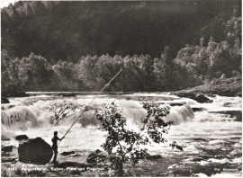
Vosso
There is probably no bigger salmon to be found in the whole wide world than in Vosso. The average size varies from season to season of course, but for many years this fish has had an average weight of over 10 kilograms. Thumping big ones of 30 kg. have been fished from the river, but one must go back to the 1940s for the last salmon of this size last that was caught.

Geitaknottane
Many travellers between Mundheim and Gjermundshamn are captivated by the expansive view toward Øynefjord, Varaldsøy and Folgefonna. The barren pine forest on the slopes on the upper-side of the road is not seen by many. Who would think that this area is home to rare species of plants and animals, creatures who have made their homes here for thousands of years?

Tokagjelet
There is a sharp transition between the wide valley at Kvamskogen and the narrow Tokagjelet. The transition is no less dramatic when we come out of the crooked tunnels far down in the canyon, and the open Steinsdalen valley spreads out before us. The canyon both separates and joins together different epochs in western Norway's history.

Dyrskard
Right from the start the road across Haukelifjell was a road from “fjord to fjord”, from the bottom of Sørfjorden to Dalen in Telemark. The connection between Røldal-Haukelifjell was considered so important by Stortinget (Parliament) that the road construction Odda-Dalen was approved already in 1853.


Reinsnos
The mountain settlement Reinsnos is situated at nearly 700 metres above sea level at the end of the Reinsnos lake; an entry point to the Hardanger plateau.

