- Remove Boats and seafaring filter Boats and seafaring
- Remove Late glacial filter Late glacial
- Remove Sedimentary rocks filter Sedimentary rocks
- Remove Maritime environments filter Maritime environments
- Remove Defense filter Defense

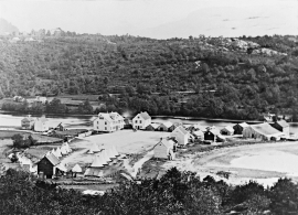
Osøyro
The coastal settlement of Os begins to take form in the middle of the 1800s. This is when craftsmen and traders begin to settle at the river delta.
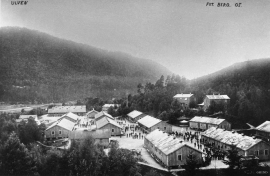

Ulven
In the region of Ulven phyllite occurs with Hordaland's youngest fossils, and a beautiful quartz conglomerate. The phyllite and conglomerate got squeezed into the bottom of an ancient oceanic crust, made of gabbro and greenstone, in the heart of the Caledonide mountain chain.


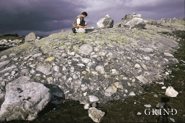
Skånevik- moraine
In Skånevik there are marks left from the ice edge that advanced during the thousand-year cold spell (Younger Dryas) that marked the end of the Ice Age roughly 11 500 years ago. The glacier first proceeded out into Åkra Fjordand and around Vannes and thereafter sent an arm in toward Skånevik. Here, the glacier lay down an end moraine up against the mountainside.

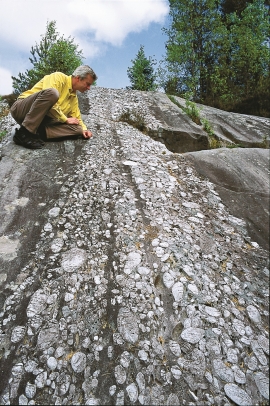
Sandviksfjellet
On Sandviksfjellet there are old boulders that have been made into mountains. The stones have been stretched out or squeezed together between huge slabs of rock, during slow, but powerfulprocesses of transport. This conglomerate shows, in quite a special way, the enormous powers that were active during the collision between Norway and Greenland over 400 million years ago.

Melderskin
MELDERSKIN - ONCE A NUNATAK? Melderskin, the towering and majestic landmark at Rosendal, rises 1462 metres above sea level. The top area is smooth, but slightly inclined. Geologists think that the area is a remnant of a weakly undulating landscape, that originated near the sea, long before the Ice Age set in.

