- Remove Quarns and mills filter Quarns and mills
- Remove Sediments filter Sediments
- Remove Vernacular arts filter Vernacular arts
- Remove Burial mounds filter Burial mounds
- Remove Lakes, rivers and river networks filter Lakes, rivers and river networks

Lona
One does not need much imaginationto see that where the river bends down in Røssebotnen, there has once been a lake. The landscape tells this - more clearly than any book.

Bjellandsvatnet
Lake Bjellandsvatnet is one of the richest wetland areas in Sveio. But, everything has its limit, and the supply of nutrients can be too much. This is what was about to happen in Lake Bjellandsvatnet.
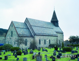
Fana church
In the Middle Ages the stone church in Fana was a place for pilgrimage, containing a miraculous silver crucifix that could heal the sick. A hill to the west of the church is still called Krykkjehaugen (the crutch hill); according to belief this is where the sick threw away their crutches. Perhaps this church, lying where it does at the old half county boundary , also held a special position in relation to the district churches in the county.

Frøyset river network
Frøyset river network is protected from power station-building - not because of its pristine nature - but because it is a typical river network for this part of western Norway.

