- Remove Precipitation filter Precipitation
- Remove Middle age filter Middle age
- Remove Lakes, rivers and river networks filter Lakes, rivers and river networks
- Remove Granvin, frå 2020 del av nye Voss herad filter Granvin, frå 2020 del av nye Voss herad
- Remove Odda, frå 2020 del av nye Ullensvang kommune. filter Odda, frå 2020 del av nye Ullensvang kommune.
- Remove Fjell, frå 2020 del av nye Øygarden kommune filter Fjell, frå 2020 del av nye Øygarden kommune

Granvinsvassdraget
After the ice age, Granvin Fjord reached all the way up under Skjervsfjossen waterfall. Just a thousand years later, as a result of the rising of the land after the ice melted, this whole inner part of the fjord freed itself of the sea and became Granvinsvatnet lake. In spite of this rise in elevation, this waterway is still navigable for fish: Sea trout have wandered into Granvinsvatnet in more recent times and evolved to become freshwater trout. And salmon and sea trout made the journey 13 kilometres up the Storelvi river.

Fjell river network
There are many river networks out by the coast and they tend to be small and unassuming. The farmer has relied upon the watercourses to run his mill and saw, and it may be that the trout have given him a good source of food in years when the ocean fish failed. In our time, these river networks are being rediscovered for their value in recreation and outdoor life, and several places, tourist trails have been built in order to fully enjoy them.

Høybøen
In connection with the planned developments in the oil sector at Vindenes around 1980, excavations were carried out under the auspices of Bergen Historical Museum. Exceptionally interesting traces of an old farm at Høybøen then came to light. These were the remnants of a farm where there had been two houses containing several rooms.


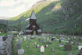
Røldal
The stave church in Røldal was one of the key pilgrimage churches in West Norway. The church was probably built between 1250 and 1350, and in the high Middle Ages Røldal was the most important destination for pilgrims in the country beside the Nidaros cathedral. It was the crucifix that attracted people to midnight mass on midsummer night. That was when it excreted its miraculous sweat.

Øvre Folkedal
Folkedal, which today is like a small “detour” from the main highway, was in the Middle Ages centrally situated in one of the most important roads between Hardanger and Voss. This is the road that Olav Haraldsson travelled in 1023, when he came from the royal farm at Avaldsnes for a meeting with the Voss inhabitants about the new belief. The road passes across the mountain pasture Krossaset and down Bordalen to Vangen.

