- Remove Smallholdings filter Smallholdings
- Remove Maritime environments filter Maritime environments
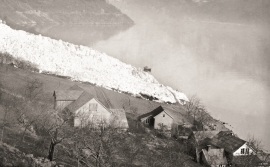
- Remove Avalanches and rock falls filter Avalanches and rock falls
- Remove Eidfjord filter Eidfjord
- Remove Hydro power filter Hydro power
- Remove Bømlo filter Bømlo
- Remove Ullensvang, frå 2020 del av nye Ullensvang kommune. filter Ullensvang, frå 2020 del av nye Ullensvang kommune.
- Remove Large landforms filter Large landforms
- Remove Bergen filter Bergen
- Remove Basement rocks filter Basement rocks


Åsane
Most associate Åsane with ridges, naturally enough (the Norwegian word for "ridge" is "Ås"). A lesser noticed trait in the landscape are the unusual flat areas that lie between the ridges. The Dalselva River, which was channeled at the end of the 1950s, runs down only 2.5 metres from Lake Langavatnet by Vågsbotn to Flatevad, where it goes over into rapids by Fossekleiva. The layers of gneiss stand nearly vertically, and the mountain surface is so even that one might think it had been planed with a planer.

Måbødalen- geology
The old pack road had 1500 steps, where cars today gas through the mountain. The time of this hard work is over, and of getting used to the steep terrain, as well; only the view from the top is much the same as before. Vøringsfossen in summer is one of Western Norway’s biggest natural wonders. It marks the transition between the older, open part of the Sysendalen valley and the younger, narrow and winding valley of Måbødalen.


Siggjo
Siggjo is a cone-shaped, volcano-like mountaintop in the part of Hordaland where one finds the best preserved volcanic rocks. The rock types originate from one or several volcanoes that spewed out glowing lava and ash. But, the shape of the mountain, as it appears today, formed later and by completely different forces.

Kvalvikane
In Ålvik quartz has long been used to produce ferro-silicon. The quartz was collected from the other side of the fjord, from the mountainside above Kvalvikane.