- Remove Smallholdings filter Smallholdings
- Remove Igneous rocks filter Igneous rocks
- Remove Defense filter Defense
- Remove Churches filter Churches
- Remove Austevoll filter Austevoll
- Remove Fitjar filter Fitjar
- Remove Place filter Place
- Remove Fusa, frå 2020 ein del av nye Bjørnafjorden kommune filter Fusa, frå 2020 ein del av nye Bjørnafjorden kommune

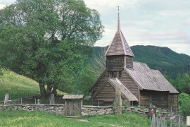
Holdhus church
The old church at Holdhus is one of the oldest timbered churches left in the west of Norway. The new church at Eide, built in 1889, replaced the church location from the Middle Ages. As the small, tarred church lies today, in the hilly landscape at Holdhus, it was taken over by the Society for the Preservation of Norwegian Ancient Monuments, who obtained title to the property in 1900 from Hans Holdhus.


Fitjarøyane
If we study the group of islands south of Selbjørns Fjord from the air or on a sea map, we will notice that many of the islands are elongated and lie systematically in rows. The islands are divided by long sounds, for example Trollosen, Nuleia and Hjelmosen, which are oriented in a south-southeast to north-northwesterly direction.

