- Remove Small landforms filter Small landforms
- Remove Maritime environments filter Maritime environments
- Remove Askøy filter Askøy
- Remove Chieftains and royal lines filter Chieftains and royal lines
- Remove Late glacial filter Late glacial
- Remove Kvinnherad filter Kvinnherad
- Remove Voss, frå 2020 del av nye Voss herad. filter Voss, frå 2020 del av nye Voss herad.
- Remove Fitjar filter Fitjar
- Remove Churches filter Churches

Ølve
Ølve has a special soil type. Here one finds an extra hard clay soil. This is especially noticed by those who work with excavating for building foundations and the like. Often it is necessary to use especially big digging machines and sometimes even dynamite in order to break up the compact masses. The reason for this is the growth of the glaciers toward the end of the Ice Age: The clay, that was first deposited in front of the glacier, came under great pressure when the glacier later grew and slid out over the clay.

Ænes
Ænes has been one of the prosperous farms at the Mauranger Fjord in medieval times. At the time of Harald Gilles, around 1130, we hear of GAUT at Ænes. The noble families around the Hardanger Fjord were prominent in the political sphere from early on, and it is obvious that the fine and openly situated farm at Ænes was also a good place for a Church.
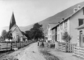
Vangskyrkja
Vangskyrkja (Vangen church) is the largest of the medieval churches in Hordaland; one of the four “fjordung” churches in the county. A royal letter from 1271 shows that the church was under construction at this time. Vossevangen at Vangsvatnet, where the wide and expansive valleys of the Voss communities meet, was the natural location for a church.

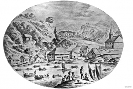
Strusshamn
On the south side of Askøy, just west of Bergen, lies Strusshamn. The sheltered bay is one of the best harbours in Byfjorden, on the route south. At the time of the sailing ships the harbour could be full of vessels from Bergen and abroad, lying in wait for favourable wind. Old anchoring rings from 1687 bear witness to this. Strusshamn was a quarantine harbour for ships that came sailing in with the yellow pest flag flying.


Skorpo
Skorpo - Polished by glaciers and meltwater


Melderskin
MELDERSKIN - ONCE A NUNATAK? Melderskin, the towering and majestic landmark at Rosendal, rises 1462 metres above sea level. The top area is smooth, but slightly inclined. Geologists think that the area is a remnant of a weakly undulating landscape, that originated near the sea, long before the Ice Age set in.


