- Remove Small landforms filter Small landforms
- Remove Maritime environments filter Maritime environments
- Remove Askøy filter Askøy
- Remove Os, frå 2020 del av nye Bjørnafjorden kommune filter Os, frå 2020 del av nye Bjørnafjorden kommune
- Remove Chieftains and royal lines filter Chieftains and royal lines
- Remove Bømlo filter Bømlo
- Remove Place filter Place
- Remove Granvin, frå 2020 del av nye Voss herad filter Granvin, frå 2020 del av nye Voss herad
- Remove Road constructions filter Road constructions
- Remove Lakes, rivers and river networks filter Lakes, rivers and river networks

Granvinsvassdraget
After the ice age, Granvin Fjord reached all the way up under Skjervsfjossen waterfall. Just a thousand years later, as a result of the rising of the land after the ice melted, this whole inner part of the fjord freed itself of the sea and became Granvinsvatnet lake. In spite of this rise in elevation, this waterway is still navigable for fish: Sea trout have wandered into Granvinsvatnet in more recent times and evolved to become freshwater trout. And salmon and sea trout made the journey 13 kilometres up the Storelvi river.


Lussand-roadwork
The road along the north side of the Hardanger fjord - between Øystese and Eide in Granvin – was literally built “by hand”. The construction work started in February 1933, and on 9 October 1937 Crown Price Olav opened the stretch of road between Øystese and Ålvik at Fyksesund bridge.


Skjervet- road construction
The road between Eide in Granvin and Voss is one of the oldest roads mentioned in the Middle Ages. In a diploma from 1343 from Voss regarding distribution of road works, we also find mention of the road to Angr (the Granvin fjord).
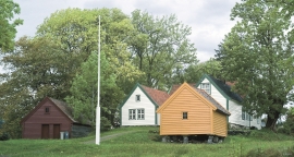
Ferstad
Ferstad is well worth a visit. The farm lies on a little hillock south of Lekven: a beautiful official residence from the 1700s.

