- Remove Museums, nature conservation, cultural heritage filter Museums, nature conservation, cultural heritage
- Remove Arkeologi filter Arkeologi
- Remove Farm sites filter Farm sites
- Remove Livelihood and Craftsmanship filter Livelihood and Craftsmanship
- Remove Museum filter Museum
- Remove Settlements, Villages, Towns filter Settlements, Villages, Towns
- Remove Churches filter Churches
- Remove Hydro power filter Hydro power
- Remove Archaeology filter Archaeology

Gullbrå
From written sources we know that the farm Gullbrå was in use early in the 1600s. The Apostolic church in Bergen owned land here that it rented out, but even early in the 1600s some of the land was in private ownership. Eksingedalen then belonged to Modalen parish, which was under Hamre parish. In 1723 the Apostolic church still had properties here, and Ivar and Lars were farmers.

Vikøy
Through Adolph Tidemand’s detailed close-ups of smokehouses in Kvam, the vicarage in Vikøy, where he lived during his painting trips through Hardanger, has obtained a central position in the Norwegian national romanticism.

Norheim
Norheim, “the farm by the narrow sound” is mentioned in a diploma from the Middle Ages and in an inheritance document. This is one of the large farms in Hardanger, of those that belonged to the powerful families; Sandven in Kvam, Torsnes in Jondal, Aga in Ullensvang and Spånheim in Ulvik.

Nottveit
In one of the frame-built haysheds at Nottveit, at holding No. 3, we discover that several of the staves have a medieval look, with large dimensions and carefully rounded edges. According to tradition, it was the farms Nottveit and Mostraumen that supplied the timber for the stave church at Mo, and it is not unlikely that these farms received the old timber in return when the new church was erected there in 1593.

Otterstad
Tthe Otterstad farms lie in the innermost part of Mofjorden, on the northwest side of the river. The row of stave-built boatsheds that belong to the farm were probably constructed a little after the middle of the 1800s. Both here and on the Mo side, the boatsheds were important storage places at the seashore; wood and other farm products intended for the town; corn and merchandise in return.

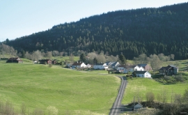
Havrå
In the sunny, steep fjord landscape along Sørfjorden on the east side of Osterøy is the farm Havrå. The small “hamlet” is one of the few undisturbed farming communities that gives us the impression of the large communal yards in West Norway in the 1700s, with houses built close together and strips of arable land.

Øvre Folkedal
Folkedal, which today is like a small “detour” from the main highway, was in the Middle Ages centrally situated in one of the most important roads between Hardanger and Voss. This is the road that Olav Haraldsson travelled in 1023, when he came from the royal farm at Avaldsnes for a meeting with the Voss inhabitants about the new belief. The road passes across the mountain pasture Krossaset and down Bordalen to Vangen.
Isdal
Isdal one of the few clustered settlements left in the Hordaland communities, after the extensive changes taking place around the turn of the former century, which broke up the shared farms and the old intermixture of strips. The old, low houses are situated in a compact enclosure, which is very noticeable in the landscape when you travel the main road north from Knarrvik.

Frøystein
The farm Frøystein by the Ulvik fjord is commonly called Fryste. In 1614 the name was written Frøstemb – an obvious Danish influence – and the form Frøsten was used up until the land register in 1886 and 1907. It is probable that the name of the farm originally was Frystvin; a vin-name. Thus it has no connection with neither Frøy (Norse fertility god) nor stein (stone).

