- Remove Place filter Place
- Remove Landscape filter Landscape
- Remove Granvin, frå 2020 del av nye Voss herad filter Granvin, frå 2020 del av nye Voss herad
- Remove Stord filter Stord
- Remove Wildlife filter Wildlife

Granvinsvassdraget
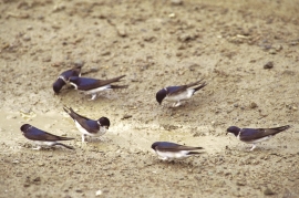
After the ice age, Granvin Fjord reached all the way up under Skjervsfjossen waterfall. Just a thousand years later, as a result of the rising of the land after the ice melted, this whole inner part of the fjord freed itself of the sea and became Granvinsvatnet lake. In spite of this rise in elevation, this waterway is still navigable for fish: Sea trout have wandered into Granvinsvatnet in more recent times and evolved to become freshwater trout. And salmon and sea trout made the journey 13 kilometres up the Storelvi river.


Skjervet- river theft
At the end of the last ice age the ice flowed out of Hardanger fjord in such a fury that it forced the meltwater from Voss to run back uphill toward Granvin. The glacier from Raundalen down the windy valley along the Vosso to Bolstadøyri went too slow to make the turn.
Digernes
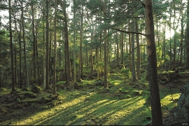
Despite the fact that the animal life on Stord is better investigated and studied than most other places in Hordaland, we were not clear about the diversity in Digernes forest until the triple junction was almost finished being planned.

Huglo
The majority of Huglo is bare rock. A bit of dwarf pine forest is the only vegetation able to put down roots. Along the west- and east sides, to the contrary, the landscape is unusually green and lush. The reason lies both in the bedrock and in the ice that covered the area 12 000 years ago.

Sævarhagsvikjo
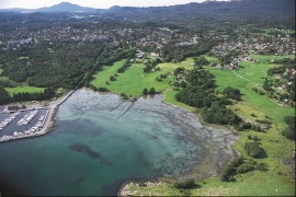
Most of the shoreline toward the sea in Sunnhordland is stony and steep. Therefore, flat tidal areas are scarce, yet these are especially important for the wading birds when they need food and rest during their autumn migrations. Sævarhagsvikjo is the biggest flat tidal area in Sunnhordland.

