- Remove Cultural landscapes filter Cultural landscapes
- Remove Samnanger filter Samnanger
- Remove Archaeological findings filter Archaeological findings
- Remove Chieftains and royal lines filter Chieftains and royal lines
- Remove Vaksdal filter Vaksdal
- Remove Øygarden, frå 2020 del av nye Øygarden kommune. filter Øygarden, frå 2020 del av nye Øygarden kommune.
- Remove Masfjorden filter Masfjorden
- Remove Radøy, frå 2020 del av nye Alver kommune. filter Radøy, frå 2020 del av nye Alver kommune.


Blomvågen
"One of the big scientific sensations", was the title in the Bergens Times newspaper on the 22nd of November, 1941. It was the geologist Isal Undås who had been interviewed by the newspaper. He thought that he had discovered a 120 000 year old whale bone, remains of life from before the last Ice Age.
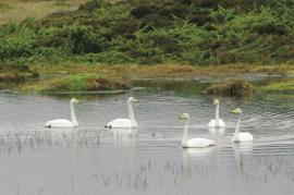
Tjeldstømarka
There is no place in Hordaland where there are so many over-wintering song swans as in Tjeldstømarka. And there are few places in the county that have had this birdfowl as a guest for as long.

Matrehola
On a large gravel terrace in Matredalen (the Matre valley), a couple of kilometres from the coastal settlement Matre, lies Storseterhilleren, at the end of a large stone block that came rushing down from the mountain. The Matre river runs just over 100 metres to the east of the cave.


Fosnstraumen
At the southern end of the bridge between Radøy and Fosnøy archaeologists found an unusual Stone Age settlement. There was a thick “cultural layer” here with the remains of the waste dumps of a hunting people. The place was called Kotedalen. Here they came, one group after the other, and settled for some weeks, some months, or maybe years before they went on, leaving the settlement deserted. Time after time it happened. At least 16 settlement phases have been identified, stretching over 5,500 years.


Toska
The peat bogs on Toska have been mined for peat since 1946, when the island got electricity. In this treeless coastal landscape, peat was the most important source of energy, and this took quite a toll on the bogs.

Dale farm
The Dale farm lies well situated on the gravel by the river, below the mountain Beitelen. But a few stone throws further north, on the wide expanse behind the houses, there has been an older farmstead. Here there have been found a number of cooking hollows, pole holes, an old road and traces of something believed to have been a palisade. Finds from this oldest farmstead may be dated to the time of the migrations, 400-600 years A.D.


