- Remove Quarns and mills filter Quarns and mills
- Remove Archaeological findings filter Archaeological findings
- Remove Igneous rocks filter Igneous rocks
- Remove Austevoll filter Austevoll
- Remove Trading posts and guesthouses filter Trading posts and guesthouses
- Remove Masfjorden filter Masfjorden
- Remove Tysnes filter Tysnes
Bakholmen
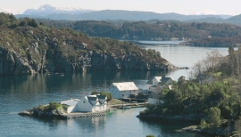
On Austre Bakholmen, a small islet of around 15 acres between Hundvåko and Drøni, lies the oldest trading centres in Austevoll. For a long time this was a court location and it was a natural centre in this archipelago.


Eidsbøen
Where the school and the sports facility lie at Eidsbøen there was previously a bog surrounded by small hillocks. More than 1000 years ago this was a holy place, where the dead were buried.
Krosshamn
Krosshamn lies in the shipping lane northeast of Hundvåkøy, near Sandtorv. The name probably derives from the fact that this is Austevoll’s harbour situated nearest to Korsfjorden.
Kvalvåg
Kvalvåg on Stolmen is first mentioned as a trading post in 1655, and in 1731 the owner Jens Meyer, was granted a royal trading privilege.

Matrehola
On a large gravel terrace in Matredalen (the Matre valley), a couple of kilometres from the coastal settlement Matre, lies Storseterhilleren, at the end of a large stone block that came rushing down from the mountain. The Matre river runs just over 100 metres to the east of the cave.


Espevik
220 million years ago, glowing hot molten rock masses intruded into fractures in the earth's crust in the outer parts of Hordaland. Some of these are believed to have reached the surface and formed lava flows, which since have been eroded away by wind and weather. But, most of these flows solidified into diabase sills before they got to the surface.

