- Remove Quarns and mills filter Quarns and mills
- Remove Wetland filter Wetland
- Remove Fitjar filter Fitjar
- Remove Etne filter Etne
- Remove Austevoll filter Austevoll
- Remove Fish filter Fish
- Remove Thrust sheets filter Thrust sheets
- Remove Bronze age filter Bronze age


Etnedeltaet
During the latter half of the 1900s the big natural river deltas on Westland disappeared. Until the 1980s there was still a small, but significant remnant of the original river delta from the Etneelva river, but today most of this, too, is industrial land.

Etne river
There is still life to be found that is just “hanging on a string”. The Etne river has been the most important river for sports- fisherman in Hordaland after salmon fishing in Vosso was temporarily forbidden. As late as 2000, 4 tonnes of salmon and sea trout were taken out of the Etne river, the best fishing for 10 years. In the whole of the county there are only 15-20 rivers that can compete with this haul.

Helgaberget
Helgaberget – the holy hill – is a little rocky crag which thrusts itself a few metres above the terraced surface of Støle. The surface of the rock is strewn with figures inscribed in the rock and it was, as far as one can judge, a cult centre in the Bronze Ages. The name could indicate that the tradition of holiness can have lasted for almost 3,000 years.


Rimbareid- Vestbøstad
At nesting time you cannot avoid hearing the calls of the curlew or the snipe along the narrow road through the cultural landscape from Rimbareid to Vestbøstad. And on late summer evenings, the intense song of the sedge warbler rings out over the two characteristic tarns in the area.

Rimsvarden
Rimsvarden lies high and unencumbered, an enormous stone mound on the highest top with a wide view of the Fitjar rural community. With its 30 meters across and almost 4 meters high, this is one of the largest prehistoric burial relics existing in Hordaland.
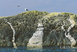
Møkstrafjordøyane
The sea keeps the bedrock in the outer skerries smooth and clean. When the bedrock is also varied and interesting, the setting is perfect for a discovery tour of these bare-faced outcrops.

