- Remove Smallholdings filter Smallholdings
- Remove Burial mounds filter Burial mounds
- Remove Sveio filter Sveio
- Remove Metamorphic rocks filter Metamorphic rocks
- Remove Sund, frå 2020 del av nye Øygarden kommune filter Sund, frå 2020 del av nye Øygarden kommune
- Remove Conservation area filter Conservation area
- Remove Farm sites filter Farm sites

Golta- Gneiss
Over thousands of years, autumn storms and strong land-driving winds have cleaned the bare rocks of Golta. The waves can beat far in over land and make it dangerous to walk along the shoreline. When the storms have calmed, the results of their work comes into view.

Golta- Long house
In the years between the wars a major registration of houses and house costumes, house construction methods, fireplaces and forms of housing clusters was started in West Norway – an ambitious mapping of everything that came under the name “Registration of Culture and Geography in West Norway”. One of the places of which material was gathered in 1938 was an old multi-room house at Golta; new and interesting material for the researchers from the Historical Museum, but well known within the local building tradition through several generations.

Einstapevoll- the farm
Einstapevoll (from einstape: “bregne” (fern)) lies on the west side of the Tittelsnes peninsula. Up to 1831 the farm was a vicarage belonging to Stord parish. The priests had leasing rights. Land rent and other fees from the farm was part of their salaries.

Haugsbø
The single unit farm without a road to it, Haugsbø, is situated on the east side of the Tittelsnes peninsula facing Ålfjorden. As far back as the Middle Ages the farm has probably belonged to Stord Parish, up to the 1800s. In 1590 it was thought to be abandoned, but in 1601 Mickel Hougsbøe paid a tithe on the farm.

Hopsfjellet
On June 2nd, 1992, a big forest fire broke out in Sveio. The fire started southeast of Hopsfjellet. In a strong wind the flames spread quickly northward. Houses on the other side of the highway were threatened, but escaped unscathed. The burned area, which is easily visible about a 5 minute's drive south from the tunnel at the triple- junction, was made into a nature reserve in 1998. The intention was to ensure that the re-establishment of plant- and animal life would take place without disturbance.
Tjernagel
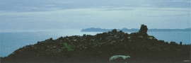
For almost three thousand years Tjernagelshaugen (the Tjernagel cairn) has lain as a landmark at the Bømlo fjord. The poet Torarin mentions the cairn in his account of Knut the Mighty, who in the year of 1028 sailed from Denmark to Nidaros: “And in front of the old cairn at Tjernagel sailed soldiers sharp with peace”.

Bjellandsvatnet
Lake Bjellandsvatnet is one of the richest wetland areas in Sveio. But, everything has its limit, and the supply of nutrients can be too much. This is what was about to happen in Lake Bjellandsvatnet.

Einstapevoll- slates
“On the country of Wallestrand…the rock almost everywhere appears to be of a slate-like substance, be it at the seashore, on the farms or in their distant fields”.

