- Remove Museum filter Museum
- Remove Vernacular arts filter Vernacular arts
- Remove Iron age filter Iron age
- Remove Defense filter Defense
- Remove Farm sites filter Farm sites
- Remove Bømlo filter Bømlo
- Remove Trading posts and guesthouses filter Trading posts and guesthouses
- Remove Vaksdal filter Vaksdal
- Remove Hydro power filter Hydro power

Dale farm
The Dale farm lies well situated on the gravel by the river, below the mountain Beitelen. But a few stone throws further north, on the wide expanse behind the houses, there has been an older farmstead. Here there have been found a number of cooking hollows, pole holes, an old road and traces of something believed to have been a palisade. Finds from this oldest farmstead may be dated to the time of the migrations, 400-600 years A.D.

Gullbrå
From written sources we know that the farm Gullbrå was in use early in the 1600s. The Apostolic church in Bergen owned land here that it rented out, but even early in the 1600s some of the land was in private ownership. Eksingedalen then belonged to Modalen parish, which was under Hamre parish. In 1723 the Apostolic church still had properties here, and Ivar and Lars were farmers.

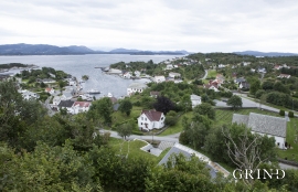
Espevær- the Trading Post
In the sea west of Bømlo lies Espevær, half an hour’s rowing trip across the sound from Vespestadvågen. This is a well-run and well-maintained local community, established on the back of the rich herring fisheries in the 1850s. It is fishermen, skippers and the tradesmen who have made their mark on the culture in Espevær, with their contacts to the south towards Haugesund and across the North Sea to the British Isles.
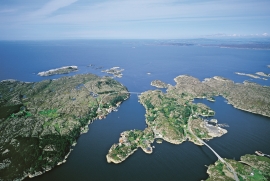
Brandasund
On Gisøya Island, on the west side of Brandasund Sound, there is a very privileged trading post and traveller's Inn from the 1600s, with the North Sea as its nearest neighbour. In 1991 a road was built over Bømlo out to these islands, but for thousands of years the sheltered harbour here was a main stopping place along the outer coast. During the great herring period of the 1700s and 1800s, Brandasund was a centre for the herring fisheries on the Sørafeltet fishing grounds. Today, the area belongs to the municipality of Bømlo.
Mosterhamn
Mosterhamn is one of the old privileged trading posts situated centrally in the shipping lane, whether the ships sailed on Langenuten, Nyeleia through Fitjar or into the Hardanger Fjord. From prehistoric times Bømlo and Moster were the first landing places when arriving from the west; a landscape with good harbours.

Dale power station
In 1923 Bergenshalvøens Kommunale Kraftselskap (BKK) expropriated large areas for power plants and development of hydropower started soon afterwards. Dale power station with the two first aggregates, each of 14 MW was put into operation on 17 November 1927. In the supply reservoir in Storefossen 5152 cubic metres of concrete were cast, and a modern and well-equipped power station was built.

Eksingedalen- hydropower development
Water discharge at the outlet of the Ekso into Eidsfjord was halved after the big hydropower development in the mountainous area between Modalen and Eksingedalen and further southward toward Evanger in the 1960s, 70s and 80s. In an attempt to amend the changed environmental conditions in the waterway the developer built 35 small dams in the river.