- Remove Museum filter Museum
- Remove Vernacular arts filter Vernacular arts
- Remove Iron age filter Iron age
- Remove Defense filter Defense
- Remove Farm sites filter Farm sites
- Remove Bømlo filter Bømlo
- Remove Trading posts and guesthouses filter Trading posts and guesthouses
- Remove Vaksdal filter Vaksdal
- Remove Eidfjord filter Eidfjord

Hæreid- archaeology
The biggest prehistoric burial site in Hordaland is situated at Hæreid. On top of the terrace expanse, inside the fine birch garden, is where they lie, the mounds and stone piles, on their own or in clusters, large and small, round and elongated – at least 350 in all.

Halne
At Halnefjorden, a few hundred metres east of Halne mountain lodge, lie the remains of two stone sheds – Halnelægeret. Some generations ago the cattle drovers stopped here in the summer; they were the cowboys of their time. But Halnelægeret already had a long history before the cattle drovers came.

Hjølmo
In the steep hillside in Hjølmodalen, a small side valley from Øvre Eidfjord (Upper Eidfjord), which has been a key entrance to the Hardanger Plateau, the hamlet of old farmhouses still lie clustered together. The yard is empty today, some of the houses are used in the summer, but the grass grows round all the corners.

Kjeåsen
High up above the fjord, at a height of 600m lie the two holdings at Kjeåsen. Today you can drive there by car, through a new tunnel that the power engineers in Sima have drilled. Until 1974 the only road went up the steep hillside, along iron bolted ladders across dizzying rocks – a road for the strong at heart.

Måbø
Måbø is the uppermost farm in Måbødalen. This narrow and steep mountain valley has been one of the routes from the fjord communities up to the mountain plateau from times immemorial. We are not certain of the meaning of the name Måbø. Perhaps it has its origin in an Old Norse male name Mávi, from the name for seagull, már. The last syllable “bø” means farm. Today Måbø gives us a compact close-up of the subsistence economy: the small farm with the clearance piles, stone walls and a lane that guided the animals into the yard, at the foot of the great mountain expanse.

Dale farm
The Dale farm lies well situated on the gravel by the river, below the mountain Beitelen. But a few stone throws further north, on the wide expanse behind the houses, there has been an older farmstead. Here there have been found a number of cooking hollows, pole holes, an old road and traces of something believed to have been a palisade. Finds from this oldest farmstead may be dated to the time of the migrations, 400-600 years A.D.

Gullbrå
From written sources we know that the farm Gullbrå was in use early in the 1600s. The Apostolic church in Bergen owned land here that it rented out, but even early in the 1600s some of the land was in private ownership. Eksingedalen then belonged to Modalen parish, which was under Hamre parish. In 1723 the Apostolic church still had properties here, and Ivar and Lars were farmers.

Espevær- the Trading Post
In the sea west of Bømlo lies Espevær, half an hour’s rowing trip across the sound from Vespestadvågen. This is a well-run and well-maintained local community, established on the back of the rich herring fisheries in the 1850s. It is fishermen, skippers and the tradesmen who have made their mark on the culture in Espevær, with their contacts to the south towards Haugesund and across the North Sea to the British Isles.
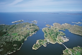
Brandasund
On Gisøya Island, on the west side of Brandasund Sound, there is a very privileged trading post and traveller's Inn from the 1600s, with the North Sea as its nearest neighbour. In 1991 a road was built over Bømlo out to these islands, but for thousands of years the sheltered harbour here was a main stopping place along the outer coast. During the great herring period of the 1700s and 1800s, Brandasund was a centre for the herring fisheries on the Sørafeltet fishing grounds. Today, the area belongs to the municipality of Bømlo.
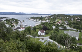
Mosterhamn
Mosterhamn is one of the old privileged trading posts situated centrally in the shipping lane, whether the ships sailed on Langenuten, Nyeleia through Fitjar or into the Hardanger Fjord. From prehistoric times Bømlo and Moster were the first landing places when arriving from the west; a landscape with good harbours.

