- Remove Small landforms filter Small landforms
- Remove Place filter Place
- Remove Sediments filter Sediments
- Remove Boat- and shipyards filter Boat- and shipyards
- Remove Industry, Energy and Natural Resources filter Industry, Energy and Natural Resources
- Remove Plant life filter Plant life
- Remove Landscape filter Landscape
- Remove Arkitektur filter Arkitektur
- Remove Thrust sheets filter Thrust sheets
- Remove Mountain plants filter Mountain plants

Halsnøy
Hadde ikkje Hardangerfjordbreen mot slutten av istida rykt fram over fjordbotnen, ville Halsnøy ikkje eksistert som éi øy, men som mange småøyar. Breen skuva framfor seg så mykje leire frå havbotnen at Brattåsen, Toftåsen, Landåsen og Svartaberg vart samla i eitt landområde.

Skorpo
Skorpo - Polished by glaciers and meltwater
Sunde
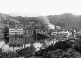
In 1852 Haktor Thorsen erected two large warehouses on one of his farms in Sunde and started trading and salting herring. This was the start of an industrial adventure that made Sunde into one of the first industrial communities in Kvinnherad.

Ølve
Ølve has a special soil type. Here one finds an extra hard clay soil. This is especially noticed by those who work with excavating for building foundations and the like. Often it is necessary to use especially big digging machines and sometimes even dynamite in order to break up the compact masses. The reason for this is the growth of the glaciers toward the end of the Ice Age: The clay, that was first deposited in front of the glacier, came under great pressure when the glacier later grew and slid out over the clay.


Hereiane
At Hereiane on warm summer days one you can walk barefoot up the hill from the fjord all the way up to 400 metres elevation. The naked, furrowed bedrock often causes travellers who see it from the north side of the fjord to wonder. Why does it look like this, and why is there so little that grows here? It is a long way to the heavy metal industry in Ålvik and Odda, and there hasn’t been a forest fire in modern times.

Jonstein
When high school student Arne Handegard collected plants for a herbarium in 1962, he didn’t know what kind of rarity he had pressed into his notebook. 30 years later he attended a botanical lecture, where a picture was shown of a plant he recognized: “Norwegian Sagebrush, which in Norway is only found in a large area of Dovre and in Trollheimen, and in a little area in Ry county”. Arne Handegard raised his hand: “That plant grows on Mt. Jonstein in Jondal”.

Eikelandsosen
"So many and such big potholes as are found at Eikelandsosen, we don't see other places in western Norway, and as beautifully polished as the mountainside is along the river up to Koldal , one would look a long time to see anywhere else. There is much to dazzle a geologist's eyes. If only these features could bring others the same joy!"

Skjelbreid
On the east side of Lake Skjelbreidvatnet, clearly visible along the road from Eikelandsosen, we notice a farm on a terrace above a grassy hill. The hill has the form of a broad shield; Skjelbreid (" Broad Shield") is the name of the farm.

Vinnesleira
Bays that are shallow far out into the sea, with fine sand and clay, are rare in Hordaland. Where they are found, the reason is usually that the edge of the glacier made smaller advances or stopovers when it calved back at the end of the last Ice Age. This is what happened at Vinnesleira.

