- Remove Small landforms filter Small landforms
- Remove Middle age filter Middle age
- Remove Eidfjord filter Eidfjord
- Remove Conservation area filter Conservation area
- Remove Mountain farms filter Mountain farms
- Remove Bergen filter Bergen
- Remove Hydro power filter Hydro power
- Remove Granvin, frå 2020 del av nye Voss herad filter Granvin, frå 2020 del av nye Voss herad
- Remove Farm sites filter Farm sites

Arnatveit
On the farm of Arnatveit, high up on the slope above the highway, an old smokehouse remains standing in the courtyard of the main farm property, in the place of the old common courtyard. Today this farm lies at the outskirts of a large housing estate. Most of the farmland of the other farm properties has been sold to benefit the city’s need of sites for the new community of Arna.

Bryggen
In the 1300s Bergen was a trading centre of European dimension. The town is thought to have had around 7000 inhabitants and was the largest and most important in the country. In a European context it was an average size town. At this time the most tightly built town area was still mostly east of Vågen from Holmen in the north to Vågsbotn in the south. Already in medieval times, latest in the 1340s, this area was called Bryggen.
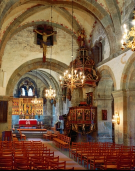
Mariakirken
Apart from the king’s estate at Holmen, Håkonshallen and the lower floors of the Rosenkrantz tower, the three parish churches in the centre of Bergen are what have been preserved from medieval Bergen: Mariakirken, Korskirken and Olavskirken (the cathedral). The Romanesque base of the tower from Nonneseter monastery church on the spit between the two Lundegård lakes can still be seen in the landscape, while the other medieval buildings now lie in ruins: the town’s oldest town hall and wine cellar at Nikolaikirkealmenning, Lavranskirken and Maria Gildeskåle between Mariakirken and Bryggens Museum and the Katarina hospital on the north side of Dreggsalmenningen.

Vågsbunnen
Vågsbotn was the name of the innermost part of the eastern part of town from Auta-almenning (today’s Vetrlidsalmenning), skirting the bottom of Vågen to Allehelgenskirken (All Saints’ Church) (at the present Allehelgensgate). In early medieval times Vågen reached almost all the way to Olavskirken (the Cathedral). It was a relatively wide bay inside the premonitory where Korskirken was built. The area was therefore much shorter than what is known as Vågsbunnen today.

Årstad
Alrekstad (later Årstad) is the birthplace of Bergen. The estate was an estate for Harald Hårfagre and several of his descendants: Eirik Blodøks, Håkon den gode og Olav Tryggvason. These first kings moved with their courts and guardsmen from estate to estate. From these estates the king ruled the country.

Agastølen
Whoever wanders the mountain plateau will form time to time hit upon old mountain summer farms, with solid old stone sheds, half sunk into the ground; a building tradition that has roots into prehistoric times. When we have been satiated with untouched Nature, it is somewhat comforting to come upon the old mountain chalets - they represent a type of human encroachment that we not only accept, but appreciate. They arouse a feeling of recognition and are a distinct witness to how people in the rural communities have made use of even the most remote resources.

Halne
At Halnefjorden, a few hundred metres east of Halne mountain lodge, lie the remains of two stone sheds – Halnelægeret. Some generations ago the cattle drovers stopped here in the summer; they were the cowboys of their time. But Halnelægeret already had a long history before the cattle drovers came.

Hjølmo
In the steep hillside in Hjølmodalen, a small side valley from Øvre Eidfjord (Upper Eidfjord), which has been a key entrance to the Hardanger Plateau, the hamlet of old farmhouses still lie clustered together. The yard is empty today, some of the houses are used in the summer, but the grass grows round all the corners.

Kjeåsen
High up above the fjord, at a height of 600m lie the two holdings at Kjeåsen. Today you can drive there by car, through a new tunnel that the power engineers in Sima have drilled. Until 1974 the only road went up the steep hillside, along iron bolted ladders across dizzying rocks – a road for the strong at heart.

Måbø
Måbø is the uppermost farm in Måbødalen. This narrow and steep mountain valley has been one of the routes from the fjord communities up to the mountain plateau from times immemorial. We are not certain of the meaning of the name Måbø. Perhaps it has its origin in an Old Norse male name Mávi, from the name for seagull, már. The last syllable “bø” means farm. Today Måbø gives us a compact close-up of the subsistence economy: the small farm with the clearance piles, stone walls and a lane that guided the animals into the yard, at the foot of the great mountain expanse.

