- Remove Small landforms filter Small landforms
- Remove Maritime environments filter Maritime environments
- Remove Askøy filter Askøy
- Remove Chieftains and royal lines filter Chieftains and royal lines
- Remove Meland, frå 2020 del av nye Alver kommune. filter Meland, frå 2020 del av nye Alver kommune.
- Remove Thrust sheets filter Thrust sheets
- Remove Osterøy filter Osterøy
- Remove Jondal, frå 2020 del av nye Ullensvang kommune. filter Jondal, frå 2020 del av nye Ullensvang kommune.
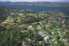
Ask- jordbær
Strawberry-growing on Askøy flourished in the beginning of the last century. When gardener Samson Eik took in the type "Seierherren" from Rosendal in 1909 for growing strawberries on Hop, it appeared that the soil and climate in this area was perfect for the mass production of strawberries.

Eldsfjellet
The eclogites in western Norway were formed when Precambrian basement rocks were squeezed and pressed down under great pressure deep under the Caledonian mountain chain. The process may well have triggered some of the deepest earthquakes the world has ever known. The clearest traces of this drama are found in and around Mt. Eldsfjellet, in peaceful Meland.


Hereiane
At Hereiane on warm summer days one you can walk barefoot up the hill from the fjord all the way up to 400 metres elevation. The naked, furrowed bedrock often causes travellers who see it from the north side of the fjord to wonder. Why does it look like this, and why is there so little that grows here? It is a long way to the heavy metal industry in Ålvik and Odda, and there hasn’t been a forest fire in modern times.

Holmeknappen
If you come by sea to Bergen and come up the Herdle Fjord, the yellow ochre marine shed at Holmeknappen is a well known landmark to starboard as you come close to the little shore settlement. In olden days Holmenknappen served important functions as a centre for a wide hinterland of the surrounding farms, warehouse, landing point, country store and later a steamer quay, a hotel (1896) and a dairy (1909). But today Holmeknappen is no longer a focal point. Transport and commercial routes have changed the old pattern

Håøy
Håøy lies centrally in one of the main shipping lanes going into Bergen --- with Håyøsund on the south side facing Meland, and Hagelsundet facing Lindåslandet. Names like Nordfarskista and Nordfarsskorane explain things. The strategic position was important in Viking times and it has been important in our days too. The beacon on Håøy can have been built in the establishment of the coastal administration in Håkon the Good’s time, about 950 AD. The defence structure of which we say remains on Håøy Summit held a critical position during Norwegian neutrality during the First World War. The defence structure was taken down in 1957.
Litlandsvatnet
Large quantities of nickel ore have been mined from Litlandsvatnet, between Lonevågen and Hosanger. The discovery was made in 1875. During the period of operation from 1882 to 1945, 4170 tonnes of pure nickel were extracted from 462 000 tonnes of ore, a large production by Norwegian standards.

Mjøsvågen
Around Mjøsvågen here is still a compact marine use area. Some of the buildings are common boathouses, but most of them also house small enterprises and workshops. This is where the farmers from Øvsthus, Mjøs, Hole and other farms have supplemented their meagre incomes as smiths, brass moulders, clog makers, chest builders and decorative painters.

Svåsand
Down by the fjord at Svåsand, close to the main highway, there is a long row of boathouses, one of the well-preserved, older boathouse locations along the Hardanger fjord. It is the farms at Svåsand that have their boathouses here, four main farms with origins far back in time.

