- Remove Small landforms filter Small landforms
- Remove Aristocracy and civil servants filter Aristocracy and civil servants
- Remove Cultural landscapes filter Cultural landscapes
- Remove Bergen filter Bergen
- Remove Archaeological findings filter Archaeological findings
- Remove Iron age filter Iron age
- Remove Thrust sheets filter Thrust sheets
- Remove Maritime environments filter Maritime environments
- Remove Defense filter Defense
- Remove Askøy filter Askøy
- Remove Tysnes filter Tysnes
- Remove Sunnhordland filter Sunnhordland
- Remove Memorial stones filter Memorial stones
- Remove Place filter Place
- Remove Midthordland filter Midthordland
- Remove Middle age filter Middle age

Arnatveit
On the farm of Arnatveit, high up on the slope above the highway, an old smokehouse remains standing in the courtyard of the main farm property, in the place of the old common courtyard. Today this farm lies at the outskirts of a large housing estate. Most of the farmland of the other farm properties has been sold to benefit the city’s need of sites for the new community of Arna.
Ask- jordbær
Strawberry-growing on Askøy flourished in the beginning of the last century. When gardener Samson Eik took in the type "Seierherren" from Rosendal in 1909 for growing strawberries on Hop, it appeared that the soil and climate in this area was perfect for the mass production of strawberries.


Bryggen
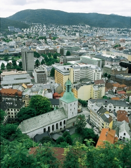
In the 1300s Bergen was a trading centre of European dimension. The town is thought to have had around 7000 inhabitants and was the largest and most important in the country. In a European context it was an average size town. At this time the most tightly built town area was still mostly east of Vågen from Holmen in the north to Vågsbotn in the south. Already in medieval times, latest in the 1340s, this area was called Bryggen.


Herdla farm
Numerous finds show that the settlement at Herdla goes back to prehistoric times, and the large estate at Herdla has enjoyed a central place in the nation’s history since High Middle Ages. As Ask, Herdla was part of the country estate Harald Hårfagre took over as he took command of the west of Norway.