- Remove Small landforms filter Small landforms
- Remove Aristocracy and civil servants filter Aristocracy and civil servants
- Remove Pollution and environment filter Pollution and environment
- Remove Fitjar filter Fitjar
- Remove Bronze age filter Bronze age
- Remove Bømlo filter Bømlo
- Remove Large landforms filter Large landforms
- Remove Maritime environments filter Maritime environments
- Remove Defense filter Defense
- Remove Askøy filter Askøy
- Remove Tysnes filter Tysnes
- Remove Sunnhordland filter Sunnhordland
- Remove Memorial stones filter Memorial stones
- Remove Place filter Place
- Remove Midthordland filter Midthordland
- Remove Middle age filter Middle age


Fitjarøyane
If we study the group of islands south of Selbjørns Fjord from the air or on a sea map, we will notice that many of the islands are elongated and lie systematically in rows. The islands are divided by long sounds, for example Trollosen, Nuleia and Hjelmosen, which are oriented in a south-southeast to north-northwesterly direction.

Herdla farm
Numerous finds show that the settlement at Herdla goes back to prehistoric times, and the large estate at Herdla has enjoyed a central place in the nation’s history since High Middle Ages. As Ask, Herdla was part of the country estate Harald Hårfagre took over as he took command of the west of Norway.
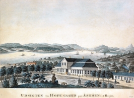
Hop- Thomas Erichsens Minde
From the 1500s Hop was noble estate for the law speaker in Bergen and Gulen judicial districts. Several of the law speakers were of noble descent, such as Hans Hansen Lillienskiold and Niels Knagenhielm. The beautiful main building, still standing, was erected by the Bergen merchant Thomas Erichsen in 1793-95. He also established a magnificent garden with an 800 metres long linden avenue reaching down to the stone boathouse at Hop harbour.
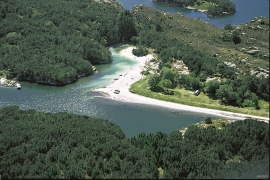
Kollevågen
From 1938 until 1975 there was a large amount of trash dumped in Kollevågen. A lot of the garbage from the city of Bergen ended up here. The dump was up to 20 metres high, and much got dumped under water in the bay. When the dump was closed, the time had come to make good on a municipal promise to make the place into a recreation area. In 1978, nets and earth were laid over the dump, and afterward it was sowed with seeds. This was quite successful, and In 1983, the recreation area was opened.


