- Remove Kvinnherad filter Kvinnherad
- Remove Boats and seafaring filter Boats and seafaring
- Remove Granvin, frå 2020 del av nye Voss herad filter Granvin, frå 2020 del av nye Voss herad
- Remove Vernacular crafts filter Vernacular crafts
- Remove Wetland filter Wetland
- Remove Middle age filter Middle age

Halsnøy Monastery
Halsnøy Monastery is situated in the midst of the lush fjord country in Sunnhordland, on one of the old spits, or “necks”, that has given name to the island. Gently sloping fields lead down to the sea on both sides, in the south towards the Kloster Fjord, to the north towards the sheltered Klostervågen.
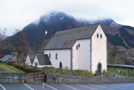
Kvinnherad Church
The stately Kvinnherad Church with its characteristic profile set out against the mighty Malmangernuten in the background, gives you a rare feeling of being present in a historic landscape as you come around Nes and face the well-kept houses at the Skåla farm. The church at Skåla is one of four “fjordungskirker” (one of four main district churches) and this farm was the centre of this coastal administration district.

Granvinsvassdraget
After the ice age, Granvin Fjord reached all the way up under Skjervsfjossen waterfall. Just a thousand years later, as a result of the rising of the land after the ice melted, this whole inner part of the fjord freed itself of the sea and became Granvinsvatnet lake. In spite of this rise in elevation, this waterway is still navigable for fish: Sea trout have wandered into Granvinsvatnet in more recent times and evolved to become freshwater trout. And salmon and sea trout made the journey 13 kilometres up the Storelvi river.

Nedre Folkedal
For many years the Folkedal scythe had a good reputation. Immediately above the highway through Folkedal there is a long brick building, on the inner side of the river. Here production of scythes went on to the beginning of the 1950s.

Øvre Folkedal
Folkedal, which today is like a small “detour” from the main highway, was in the Middle Ages centrally situated in one of the most important roads between Hardanger and Voss. This is the road that Olav Haraldsson travelled in 1023, when he came from the royal farm at Avaldsnes for a meeting with the Voss inhabitants about the new belief. The road passes across the mountain pasture Krossaset and down Bordalen to Vangen.

