- Remove Modalen filter Modalen
- Remove Maritime environments filter Maritime environments
- Remove Nordhordland filter Nordhordland
- Remove Vaksdal filter Vaksdal
- Remove Mammals filter Mammals
- Remove Currents and tides filter Currents and tides
- Remove Late glacial filter Late glacial
- Remove Quarries filter Quarries

Mostraumen
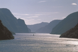
Until 1743 the people from Modal had to wait for a flood in MOSTRAUMEN before they could draw their boats up the river current, and then row back across Lake Movatnet. But, that year the flood opened a free passageway all the way to Mo. Hordaland had gained a new tidal waterway.

Nedre Helland- Sand Quarries
The three spades in the municipal coat of arms for Modalen are sand spades. Sand quarrying has brought income and employment. As much as 70,000-80,0000 tonnes of sand and gravel left the municipality each year since the turn of the millennium, to be used as cementing sand. Why is Modalen endowed with so much sand?

Eksingedalen- landscape
Eksingedalen alternates between wide, flat flood plains with good farmland, and narrow passages with waterfalls where the roads cling to the mountainsides. The alternations in the landscape are a result of the sculpturing work by glaciers over several ice ages, and the deposition of the glacial river deposits when the last glacier finally melted back.


Veafjorden
Some decades ago, Veafjord and the currents in toward the bigger rivers were the most likely places to see harbour seals in Hordaland. In the summer flocks lay on the beach and waited for the salmon to trickle in. Sometimes they also followed the fish a little way up the river.

Otterstad
Tthe Otterstad farms lie in the innermost part of Mofjorden, on the northwest side of the river. The row of stave-built boatsheds that belong to the farm were probably constructed a little after the middle of the 1800s. Both here and on the Mo side, the boatsheds were important storage places at the seashore; wood and other farm products intended for the town; corn and merchandise in return.

