- Remove Øygarden, frå 2020 del av nye Øygarden kommune. filter Øygarden, frå 2020 del av nye Øygarden kommune.
- Remove Basement rocks filter Basement rocks
- Remove Archaeological findings filter Archaeological findings
- Remove Conservation area filter Conservation area
- Remove Bergen filter Bergen
- Remove Austrheim filter Austrheim
- Remove Large landforms filter Large landforms
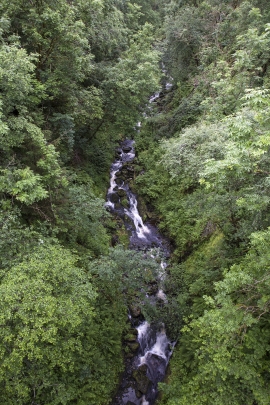
- Remove Precipitation filter Precipitation
- Remove Lichens, mosses, fungi filter Lichens, mosses, fungi
- Remove Granvin, frå 2020 del av nye Voss herad filter Granvin, frå 2020 del av nye Voss herad

Bergen- Rain City
"With its strange situation (surrounded by high mountains), this city has the advantage of a beautiful port and considerable shipping, but also the disadvantage that once on land one cannot get to the city without great inconvenience. This is because the weather in the vicinity of these high mountains is extremely unpleasant and rainy. There has even evolved an expression that is always rains in Bergen, and we have not experienced anything to counteract this saying." (a quote by the Dutch professor Fabricius after a visit to Bergen in ca. 1780).


Reppadalen
The unusual bog landscape, with enormous peat deposits surrounded by steep mountainsides, makes Reppadalen in Arna an exciting, but little visited tour destination for most of Bergen's inhabitants. Those who live in Arna, however, know to make the most of its beautiful natural splendour.


Åsane
Most associate Åsane with ridges, naturally enough (the Norwegian word for "ridge" is "Ås"). A lesser noticed trait in the landscape are the unusual flat areas that lie between the ridges. The Dalselva River, which was channeled at the end of the 1950s, runs down only 2.5 metres from Lake Langavatnet by Vågsbotn to Flatevad, where it goes over into rapids by Fossekleiva. The layers of gneiss stand nearly vertically, and the mountain surface is so even that one might think it had been planed with a planer.

Granvinsvassdraget
After the ice age, Granvin Fjord reached all the way up under Skjervsfjossen waterfall. Just a thousand years later, as a result of the rising of the land after the ice melted, this whole inner part of the fjord freed itself of the sea and became Granvinsvatnet lake. In spite of this rise in elevation, this waterway is still navigable for fish: Sea trout have wandered into Granvinsvatnet in more recent times and evolved to become freshwater trout. And salmon and sea trout made the journey 13 kilometres up the Storelvi river.


Joberget
Flowering lime is one of nature's blessings: The nectar gives clear honey. The flower is used as folk medicine. From the inner bark of the lime tree one can make strong rope. Elderly folk can still tell how they got a weather report from the lime tree. If it smelled strong, it was probably going to rain. Lime often grows together with elm, ash and other tree species of the deciduous forest. Pure lime forests are rarer. Granvin has Hordaland's biggest lime forests.

Lussand- geology
Hardangerfjorden kløyver Hordaland i to. Den etter måten rettlinja fjorden skjer seg liksom på skeive inn i landet. Ikkje som Sognefjorden og Nordfjord – dei krokar og buktar seg innover meir eller mindre vinkelrett på kysten. Hardangerfjordens utforming har røter 400 millionar år tilbake i tida, då den veike sona i fjellet, der isen seinare tok grådig for seg, vart danna. Denne sona stig på land ved Lussand.

