- Remove Dialects and arts filter Dialects and arts
- Remove Industry, Energy and Natural Resources filter Industry, Energy and Natural Resources
- Remove Landscape filter Landscape
- Remove Kvam filter Kvam
- Remove Lindås, frå 2020 del av nye Alver kommune. filter Lindås, frå 2020 del av nye Alver kommune.
- Remove Granvin, frå 2020 del av nye Voss herad filter Granvin, frå 2020 del av nye Voss herad
- Remove Bedrock filter Bedrock
- Remove Bømlo filter Bømlo
- Remove Fjell, frå 2020 del av nye Øygarden kommune filter Fjell, frå 2020 del av nye Øygarden kommune


Kjerland
On the farms Kjerland and Røynstrond, east of the river that flows into the fjord, we find many decorative painters who belong to the so-called sòlekistemålarane in Hardanger: Knut and Mikkjel Røynstrand and Johannes Jonsson Kjærland.

Lussand- geology
Hardangerfjorden kløyver Hordaland i to. Den etter måten rettlinja fjorden skjer seg liksom på skeive inn i landet. Ikkje som Sognefjorden og Nordfjord – dei krokar og buktar seg innover meir eller mindre vinkelrett på kysten. Hardangerfjordens utforming har røter 400 millionar år tilbake i tida, då den veike sona i fjellet, der isen seinare tok grådig for seg, vart danna. Denne sona stig på land ved Lussand.

Skjervet- river theft
At the end of the last ice age the ice flowed out of Hardanger fjord in such a fury that it forced the meltwater from Voss to run back uphill toward Granvin. The glacier from Raundalen down the windy valley along the Vosso to Bolstadøyri went too slow to make the turn.

Fjell river network
There are many river networks out by the coast and they tend to be small and unassuming. The farmer has relied upon the watercourses to run his mill and saw, and it may be that the trout have given him a good source of food in years when the ocean fish failed. In our time, these river networks are being rediscovered for their value in recreation and outdoor life, and several places, tourist trails have been built in order to fully enjoy them.

Haganes
The gneiss landscape west and north of Bergen viewed in profile can remind us of a saw blade of the kind that has long, slanted sides that get broken off shorter transverse sides. It has taken several hundred million years to file this saw blade, an enduring interplay between various geological processes.
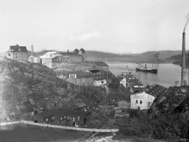
Knarrevik
Having passed well over the bridge across to Sotra you pass an industrial plant surrounded by a budding community; the mineral mill of A/S Norwegian Talc. Some of the buildings seem to have been erected in the early part of the 20th century. They are remnants of a grand industrial plant from the former boom time in the country – the economic upswing after WWI.
Power line
When the terminal at Kollsnes in Øygarden was going to be extended in the 1990s, environmental organisations, the local community and politicians demanded that a 300 Kw power line from Bergen be laid underground. It was clear that a new overground cable over this open landscape would be quite disfiguring.


Vatlestraumen
There are coal bits hidden in the sand under Vatlestraumen. These remains from a geological layer from the Jurassic Period were discovered when the undersea Bjorøy Tunnel was built in 1994. Oil- and gas reservoirs in the Troll Field in the sea west of Hordaland are from the same time. It is, nonetheless, quite surprising to find bedrock from dinosaur time inside of the outer islands of western Norway. On the Scandinavian mainland north of Denmark, there are only a very few places where one f inds rock from this time in earth history.

