- Remove Modalen filter Modalen
- Remove Maritime environments filter Maritime environments
- Remove Austrheim filter Austrheim
- Remove Nordhordland filter Nordhordland
- Remove Vaksdal filter Vaksdal
- Remove Trading posts and guesthouses filter Trading posts and guesthouses
- Remove Stone age filter Stone age
- Remove Sediments filter Sediments

Hopland
The farmhouses at holding No. 15 at Hopland are built together to form a long, continuous building, with dwelling house, hayshed and cowshed built in one row. There have been many such joined structures in the coastal communities, but today there are few remaining. If we travel to the other side of the North Sea, to the Faeroes, Shetland and the Orkney Islands, we find corresponding features in the older building traditions. We find ourselves in a large North Atlantic cultural area.
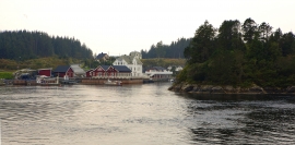
Kjelstraumen
If you take the sea route north you have several options. The various routes have been dealt with in history, and through the Middle Ages the traffic increased as well as the trading with Nordland in fish and herring, feather and down. One of the central routes passes through Kjelstraumen, in the sound between Ulvøy and Bakkøy. This has been a place for a guesthouse since 1610, with Royal Letter of Privilege, part of the large network of trading post and guesthouse locations along the coast.


Krossøy
Furthest north in the island community Rongevær, at the entrance to Fensfjorden, lies Krossøy. Belonging to the farm are the islands of Krossøy, Husøy, Kårøy, Lyngkjerringa, Søre Kjerringa, Rotøy and Kuhovet. All of them have been inhabited. On Krossøy itself today there are four holdings. The marine use environment here is one of the best preserved along the West Norwegian coast.

Mostraumen
Until 1743 the people from Modal had to wait for a flood in MOSTRAUMEN before they could draw their boats up the river current, and then row back across Lake Movatnet. But, that year the flood opened a free passageway all the way to Mo. Hordaland had gained a new tidal waterway.

Nedre Helland- Sand Quarries
The three spades in the municipal coat of arms for Modalen are sand spades. Sand quarrying has brought income and employment. As much as 70,000-80,0000 tonnes of sand and gravel left the municipality each year since the turn of the millennium, to be used as cementing sand. Why is Modalen endowed with so much sand?

Otterstad
Tthe Otterstad farms lie in the innermost part of Mofjorden, on the northwest side of the river. The row of stave-built boatsheds that belong to the farm were probably constructed a little after the middle of the 1800s. Both here and on the Mo side, the boatsheds were important storage places at the seashore; wood and other farm products intended for the town; corn and merchandise in return.

Eksingedalen- landscape
Eksingedalen alternates between wide, flat flood plains with good farmland, and narrow passages with waterfalls where the roads cling to the mountainsides. The alternations in the landscape are a result of the sculpturing work by glaciers over several ice ages, and the deposition of the glacial river deposits when the last glacier finally melted back.

Skipshelleren
For vel 7000 år sidan var Straume ein av dei beste – om ikkje den beste – veideplassen i Hordaland. Steinalderfolket som busette seg ved Skipshelleren, skjøna truleg ikkje kor heldige dei var. Mellom dei opptil 2 meter tjukke dyngjene med stein og bein som arkeologar grov fram i 1931–32, fann dei reiskapar og avfall frå fangst og matstell. Frå dette materialet har arkeologane stava seg fram til livet ved straumen.


