- Remove Arkeologi filter Arkeologi
- Remove Livelihood and Craftsmanship filter Livelihood and Craftsmanship
- Remove Sunnhordland filter Sunnhordland
- Remove Voss (tidl. kommune) filter Voss (tidl. kommune)
- Remove Landscape filter Landscape

Ølve
Ølve has a special soil type. Here one finds an extra hard clay soil. This is especially noticed by those who work with excavating for building foundations and the like. Often it is necessary to use especially big digging machines and sometimes even dynamite in order to break up the compact masses. The reason for this is the growth of the glaciers toward the end of the Ice Age: The clay, that was first deposited in front of the glacier, came under great pressure when the glacier later grew and slid out over the clay.

Ulvanosa
Some mountains have rounded shapes, while others have steep slopes and sharp edges. Ulvanosa (1246 mos.) has both. The forms reflect the type of bedrock below, and the forces that were in effect when they were formed.

The Vosso river network
The Vosso is Hordaland's main artery, she has never run more richly than in our times, and no other river in western Norway carries so much water. The increase in the amount of water comes mainly from hydropower development, due to the transfer of water from other water systems. Climate change can also be a reason that the Vosso carries more water than before.

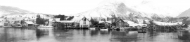
The village of Etne
Much of the sand and gravel that the town of Etne is built on was laid down at the end of the Ice Age and is evidence of melting glaciers and roaring meltwater rivers. The uncompacted material in the big terraces leave their unmistakeable mark on the wide elongated valleys.


Teigdalen
It is not surprising that there are several folk tales connected to the large and unusual scree deposit that is found at Langeland, uppermost in Teigdalen. It is said that folk have been taken into the mountains by these stone blocks and have come back and told about how the wood nymphs live. It is also said that packs of thieves hid here in the old days, both themselves and the treasures they had stolen.

Staup
The farm STAUP lies on a shelf in the terrain above Løno. From the highway E16 it is possible to glimpse the houses through the trees. The farm is without a road, and the old farmyard and the cultural landscape is very well preserved. In the 1980s grants were given to carry out maintenance work with the intention of protecting the houses in the farmyard.

Skånevik- moraine
In Skånevik there are marks left from the ice edge that advanced during the thousand-year cold spell (Younger Dryas) that marked the end of the Ice Age roughly 11 500 years ago. The glacier first proceeded out into Åkra Fjordand and around Vannes and thereafter sent an arm in toward Skånevik. Here, the glacier lay down an end moraine up against the mountainside.

Skorpo
Skorpo - Polished by glaciers and meltwater

