- Remove Basement rocks filter Basement rocks
- Remove Midthordland filter Midthordland
- Remove Hydro power filter Hydro power
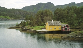
- Remove Trading posts and guesthouses filter Trading posts and guesthouses
- Remove Railroad filter Railroad
- Remove Late glacial filter Late glacial

Vinnesleira
Bays that are shallow far out into the sea, with fine sand and clay, are rare in Hordaland. Where they are found, the reason is usually that the edge of the glacier made smaller advances or stopovers when it calved back at the end of the last Ice Age. This is what happened at Vinnesleira.


Herdla – glacial deposits
The shift in the landscape is striking between the barren craggy moors north on Askøy and the green fields of Herdla, which has the county's biggest farm. The majority of Herdla, such as the island appears today, is a gift from the glacier: The glacier that advanced here over 12,000 years ago stopped at the northern tip of Askøy and took its time building up the moraine on Herdla. Since then, Herdla has been under continual transformation. The re-organisation of the loose sediment deposits continues today.
Strusshamn
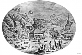
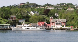
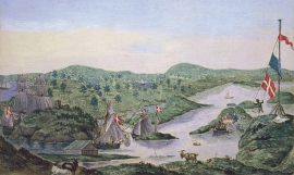
On the south side of Askøy, just west of Bergen, lies Strusshamn. The sheltered bay is one of the best harbours in Byfjorden, on the route south. At the time of the sailing ships the harbour could be full of vessels from Bergen and abroad, lying in wait for favourable wind. Old anchoring rings from 1687 bear witness to this. Strusshamn was a quarantine harbour for ships that came sailing in with the yellow pest flag flying.
Brattholmen
The old guesthouse location in Brattholmen on the east side of Litlesotra, was probably established in the first half of the 1700s. A list from 1748 mentions that the place “for some years has been inhabited by an Enrolled Sailor by the name of Peder Michelsen”. As was the case for most other military hosts, he was exempt from paying income tax.

Haganes
The gneiss landscape west and north of Bergen viewed in profile can remind us of a saw blade of the kind that has long, slanted sides that get broken off shorter transverse sides. It has taken several hundred million years to file this saw blade, an enduring interplay between various geological processes.

Langøy
Up to 1842 it was necessary to have a royal letter of privilege in order to carry out trade. According to the law only city dwellers were allowed to obtain such a privilege, and in Hordaland it was thus the citizens of Bergen who owned and ran the trading centres. In 1842, following a liberalisation of the trading legislation, the privilege arrangement was abandoned and anyone could apply to the municipal council for permission to carry out trading activity. Landøy is one of the places that were established in this period.

Frøland
Much rain, a steep drop and nearness to Bergen meant that the power-making potential of the Samnanger water system was exploited early. Samnanger was thus one of the first power-producing municipalities in western Norway. With its subsequent expansion and new power stations, about 400 gigawatts of electricity per hour were produced on average each year. This is enough to meet the energy needs of 25,000 households.
Bukken
In Christian IV’s diary from Norgesreisa (trip to Norway) in 1599, we find the reference or anecdote that is the origin of the name Bukken. A Dutch full-rigged ship once passed the mountain outcrops on the island with the guesthouse so close that a ram grazing there jumped down on a yardarm (rånokk), thus the name “Buch van Raa!”

