Published: 06.05.2019 | Author: Knut Fægri

Landet i vest – på randen av den skandinaviske halvøy. Fra Algrøyna i Fjell. (Svein Nord)
Flying over the west coast of Norway on a sunny day is a wonderful experience, perhaps most dramatic in spring or early summer, when the fields along the water's edge have turned green, as too the forests, while the north-facing mountain slopes are still cloaked in snow and the shadows appear deep blue in the mountain cirques.
Like dark rifts in the landscape, the fjords carve into the snow-white mountain massifs. The landscape is open and gentle at first, with green and brown tones and a lot of blue in the sea out in the skerries. The lines of the fjords make a pattern amidst the myriad of islands and islets, which otherwise could resemble a haphazard flock of ducks.
As your eye follows the lines inward, the forms sharpen. The mountainsides rise higher and steeper; the coastal waters grow narrower and more austere, and the sea is an even deeper blue. The early greens of spring, that first follow the sun-tainted beaches like a border along the water's edge, then spread out where the seabed rises above the water's surface. It is as if the seabed shakes off the seawater and transforms into several kilometres of green, flat valley bottom, before eventually turning its back entirely on the deep blue fjord, to climb up a sheer cliff face to the snowy white plateau, where winter still reigns for weeks to come.
The coffin lid opens
Even though the picture is dramatic, our mountain seems so solid and safe. As a Norwegian poet once wrote, "Those old mountains on the horizon, they always look the same". But, they once went through very tumultuous times. The giant mountains that rose up during the Caledonian Mountain-building event, when America and Scandinavia collided many millions of years ago, have been wearing down ever since, grain by grain. Mountains are indeed strong, but in the long run water is even stronger. Through millions of years, water eroded these mountains down to a rolling plateau with wide, tranquil valleys. Further to the south, there was more unrest. Slabs of the Earth's crust were thrust on top of each other, like ice floes in moving pack ice. The Alps towered upwards. And in the far western Norwegian Sea, the Atlantic Ocean started to widen - exerting great forces of sideways pressure. It's no wonder that even the stable old Fennoscandian Shield started to get a little ruffled. The crust got lifted along what was to become Western Norway. The interior of the country rose like a coffin lid with its hinges somewhere near the Baltic Sea. To the west it slanted steeply towards the North Sea.
This gave the relentless water something new to work on. The long, gentle valleys became suddenly steeper as the rivers ran faster and carved ever deeper. The loose material was the first to go, and after that the water eroded away at the bedrock. The rivers that ran eastward, over the "coffin lid", could more or less follow the old valleys. There wasn't a big difference since the valleys here had not become much steeper.
But to the west the erosive forces were stronger. Old valley systems were cut off and instead of following their paths eastwards, the water plunged straight down the mountainside towards the sea. The steeper the face, the more wildly the water plunged over the edge, and the greater its force in scouring downward into the bedrock. The steep rivers carved away like saw blades into the mountainside and created a whole new system of short valleys that drained westward. The intersection between the old and new valleys is visible many places, for example at the Vøringfossen waterfall. The young river sawed its way down the deep gorge that ends in the waterfall, but one's eye can easily follow the older flat valley Bjoreidalen as a continuation of the Sysendalen valley westward in the coastal mountains outwards towards the sea.
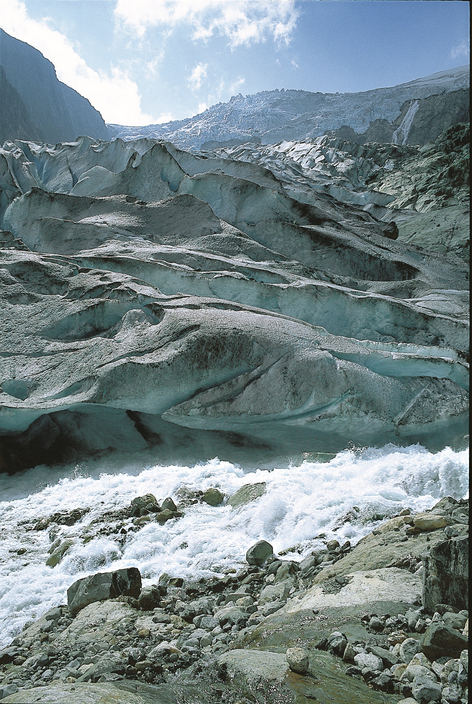
The ice takes over
It is perhaps not entirely fair to blame the forces of water for all this. Running water is powerful, but combined with snow and ice it is an even greater force to be reckoned with. When frost gets into the cracks the bedrock has little chance. That is just what happened here. When the rivers had just begun to orient themselves in accordance with the newly emerging landscape, the Ice Age started. One glacial period after the other, they followed the same general pattern: snow started to accumulate in the west, and small, isolated glaciers began to grind out small hollows in the mountains. Eventually, as a large blanket of ice settled over Scandinavia, the snow spread eastward to the big plateaus, and then lay there relatively peacefully. But from the edge of this blanket more and more ice found its way down into the crevasses in the landscape, out toward the sea. Wherever the glaciers advanced the work of landscaping went quickly. As the ice ground down through the mountainsides the steep slopes were gradually eroded back. This was crude work; there was no time for carving out broad valleys or carefully polishing the landscape.
There is one important difference between ice and water: ice can carve upwards, also, if the pressure from underneath is great enough, and where several glaciers meet this pressure can be extra strong so that depressions can be formed. If the ice is thick enough, it can just as easily carve under water as over. This can cause the depressions to be quite deep. Lake Hornindalsvatnet is 514 metres deep, for example, and Sognefjorden reaches a depth of 1300 metres. Neither lakes nor fjords in Hordaland are quite this deep, but Hardangerfjord is said to reach 900 metres at its deepest. The deepest known lake in Hordaland is Svartavatnet in the Hatteberg water system, at 167 metres.
The characteristic way in which ice carves away gives the valleys a particular shape: they have flat bottoms and steep sides, with mighty waterfalls and a series of narrow terraces, often making it difficult to find enough space to build a road. It was not unusual in the old days for people to have to climb a mountain, rather than skirting around it, in order to reach alpine villages. Nor was it possible to pass along the river. The fjord is like an elongated valley that has been submerged under the sea, and it has the same shape: like an elongated dish bounded at either end by raised terraces or sills. The innermost reaches of the fjords are often deepest, and they have a sill at the seaward end where the landscape opens up and the carving power of glaciers was not as great.
The bigger context
Now we begin to see the history of western Norway in a bigger perspective. Flat land millions of years ago, the violent rebellions of the earth's crust, first far away and then getting progressively closer. Scandinavia got turned on its edge, the water carved into the steepened slopes towards the west, then the weather deteriorated and ice took over, carving ever deeper. The ice came and went, and during interglacial periods the water continued its work. This is a recipe for how to make a mountain -and-fjord landscape. Those who are keen observers with the knowledge to interpret what they see, discover supporting evidence wherever they look. One of the best places is at the avalanche scar south of Skykkjedalen valley: Here there is a big cliff-face, like a geological picture book of dramatic proportions. It can well be compared with the walls of the Grand Canyon. Here we see the history of a landscape as it developed over hundreds of millions of years. During the last hundred thousand years water and ice dug out the story. If you gaze to the west you see that the same forces have carved the newer valleys in the old flat landscape, which in the meantime had become a mountain plateau several thousand metres high.
The fjords are the youthful features in this picture. Water and ice will continue to erode, and one day Norway as we know it today, with its mountains standing proud and tall, will once again be reduced to flatlands. This is not of concern to us and no one knows if there will be humans around then to bear witness. In the meantime, it is our young landscape with its deep fjords and steep valley sides we live with.
A border of land along the coast
There is one feature of the landscape we have not discussed, and which really does not belong in this picture. We don't in fact know how it came to be. Along the whole of our coast, from the Skaggerak to the Arctic Ocean, there is a shelf of lowland that is sometimes over, sometimes under the water. We call it the "strandflat". Strandflats are a unique feature of the Norwegian landscape, known mainly from western Norway and very few other places in the world, such as the west coast of Alaska, Antarctica, the Canadian Arctic, Greenland, Svalbard and Scotland. Mostly it consists of islands and islets and is seldom higher than 50- 60 metres high. Often the strandflat is clearly visible, sometimes it penetrates a little into the fjords, but never far. This might suggest that whatever made the strandflat happened long ago, long before the fjords attained the form they have today. Most agree that the sea probably played a role in forming them, but, when, and how? Sea ice during the Ice Age, frost shattering, or wave erosion? In our landscape the strandflat and fjord represent inseparable, yet incompatible contrasts. Where the one ends, the other begins. One must mention the fjords in the strandflat landscape, too: Hjeltefjord and Korsfjord. They are totally surrounded by the strandflats' low landscape and - at least above water - don't seem to match with what we otherwise consider a fjord landscape to be. Under the water's surface, however, they display the more typical features of fjords.
The "flat" and the "line"
The differences in the landscape influence the people who live there. The local seafaring folk, traditionally known as the "Strilen", think of the island archipelago as "the flat". They consider their world the islands that lie before them, and the sea in all its power and scope. It is a horizontal world where height is more of a theoretical notion. What lies behind is of little relevance, while all that matters lies ahead. The Strilens' world reaches perhaps as far as the wharf side at Bergen. And there it ends. The Fjord-dweller's world, the "Line", reaches as far as the the extent of the fjord; this is his primary view of the world. His world extends inwards or outwards, but never to the side, or if so it would only be a side-arm of the fjord. But here the height dimension is pronounced. It would be as natural to travel up or down as it would back and forth. The Fjord-dweller's world is simultaneously more limited yet broader. A Strilen would never wonder what he might see over the next mountain. What he enjoys most is the view from his own front porch. The Fjord-dwellers' thoughts wander out over the mountains and extend beyond the material boundaries of his daily life. He can be a dreamer, where the Strilen in contrast is said to be more of a realist, and is influenced more by the immediate world around him.
As the landscape changes from the coast inwards, the people also change. The weather changes, too, from the milder skerries with their stable moist climate and cool summers, to the inner fjord villages with their colder winters and warm summers with sun-withered fields. This change in climate is reflected in a corresponding change in soil type, which in turn leads to a different kind of vegetation.
From year-round growth to winter dormancy
On the outer coast the average temperature during the coldest month of the year - which, by the way, is February - is 2 degrees Centigrade. There is seldom much snow. Animals were able to live outside all winter long, and many of the sheep still do. They can always find something to eat, like seaweed on the shore if nothing else. The vegetation on the skerries does not have to creep along the surface in winter in order to protect itself from the cold. Many of the plants manage just fine all year long and some may even have their most important growth season in winter. There are not many places out by the sea where the earth ever completely dries out, even when there has not been any rain or fog for weeks on end. In this stable moist environment plants can grow in layers of soil that are so thin that if farther inland they be dried out and blow away. After a period of little rain things might look brown and lifeless, but a week of the usual grey weather is all it takes to turn the grass green again.
On dry raised mounds there is naturally very little soil; and what little there is forms a very thin layer over the bedrock. But it can, nonetheless, be very nutrient-rich . The typical soil type in western Norway is normally quite different: a tough, acidic humus which often makes it difficult to tell if you are walking on solid ground or a wetland. Dead remnants of plants do not decompose, but lie saturated and stiff from wetness. Bacteria and other tiny creatures, which under the right conditions make top soil from the plant remains, do not like this acidic diet. Instead, fungus takes over the job of making soil. This makes the soil even more acidic and compact and therefore even less attractive for most of the flora. But, there are some plants that thrive under just such conditions, for example, common heather. Since extensive production of just this kind of plant material in turn causes the acidic, compact soil, it becomes a vicious circle.
On the south-facing hills, which get most warmth from the sun's energy, the soil dries out a bit more and we get a lighter soil that supports many of the plant species typical for western Norway. If we were to name a plant characteristic of the outer coast it would have to be another type of heather: purple heather . Being a typical coastal plant it needs such a high winter temperature that it is found mostly out on the islands; the winters on the mainland are too cold for it.
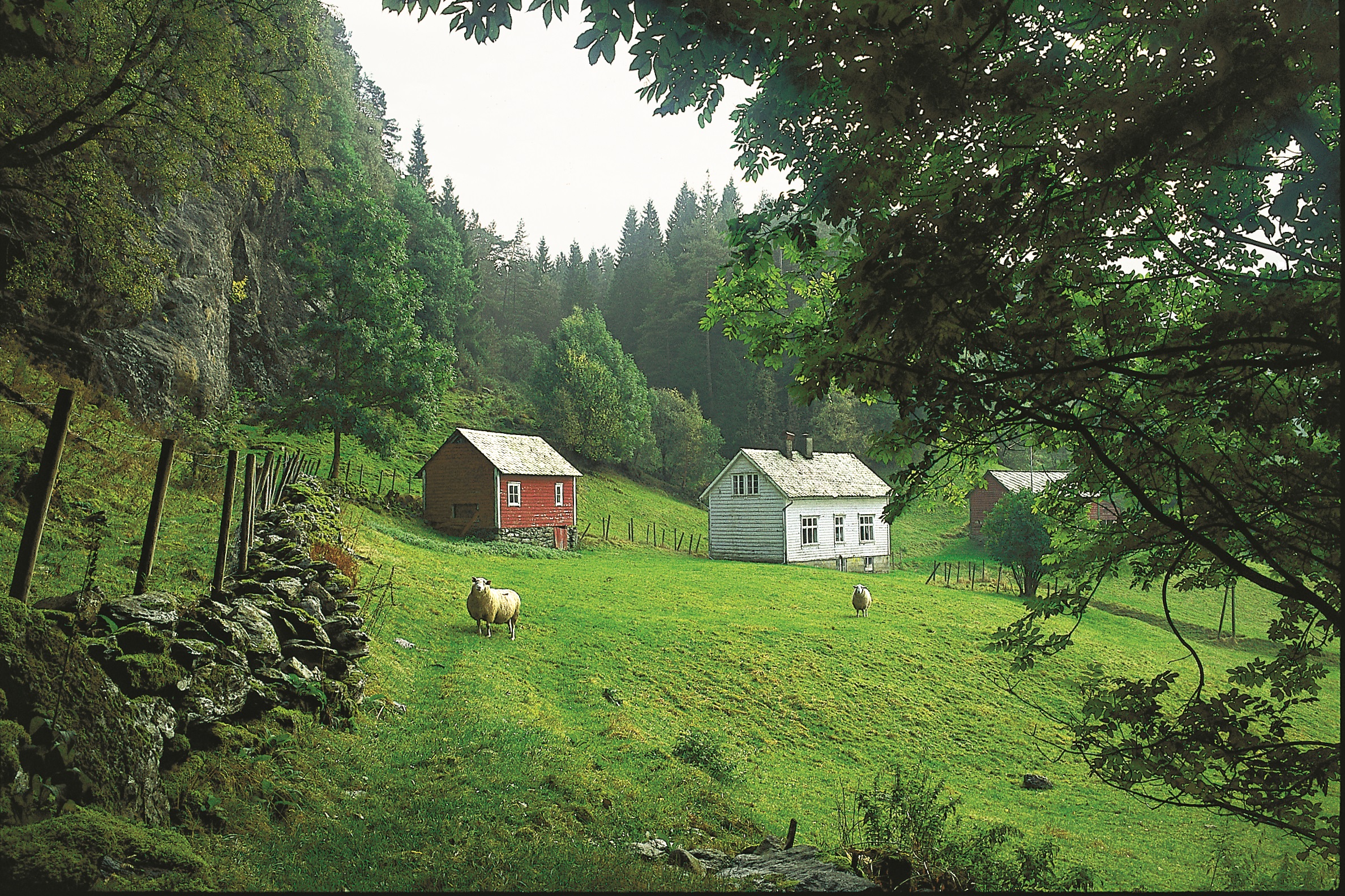
It is possible to find isolated protected areas far out towards the ocean where more warm-loving species can survive. They are the same species we find in more protected areas inland. Here we might find plants which need even more summer warmth than is to be found out in the skerries. Winter temperatures aren't as important for them, however, since many of them go into a dormant phase in winter. On the sheltered forest slopes of the inner fjords one can find basswood and oak, tree species that normally grow at more southerly latitudes.
Calcium-rich soil and Ice Age deposits
Climate type and slope direction are not alone in deciding the soil that plants and farmers of western Norway live on, and from. The geology is a third factor in the equation. The best soils are often found on limestones and calcium-rich shales, even out in areas that can otherwise be quite acidic. Geology certainly helped Mosterhavn, in the middle of a clump of limestone, become an early cultural centre in this part of the country, when Olav Trygvasson built one of his churches there. All in all, one must admire the early priesthood's sense of good land and the opportunity this presented to establish rich vicarages.
In western Norway one finds limestone only a few places and as quite thin layers in the bedrock. But it is not as bad is it might seem. Phyllite and mica schist, which are common rock types, also contain a lot of calcium. The same pertains to the loose earth that the ice age glaciers dragged here; the ice may have scraped the calcium from the bedrock further inland, so the soil can be quite good where these loose deposits are found.
Let us once more turn back the time to the ice ages. The first thing the ice age glaciers did was to scrape away the loose layer of soil that covered the land. This got swept down to Denmark and northern Germany and out into the North Sea. And there lies our old growing soils! When the glaciers melted they left behind gravel and sand, which first got eroded from the bedrock and then was used as an abrasive agent. Where the glacier ground its way forward, and then stopped for awhile, it lay down a ridge of gravel, called an "end moraine". These ridges, which are very noticeable in the landscape of eastern Norway and in Sweden, have caused geologists a lot of trouble here in the west. They are not easy to spot in our broken landscape and are even harder to follow from fjord to fjord. But with more modern methods such as aerial photographs on land and seismics in the fjords, it is now possible to trace the end moraines also here in the west. They mark the extent of the ice as it melted back.
Ice does not sort. Moraine material includes everything, from blocks as large as houses, to fine clay. Water, on the other hand, whether fresh or salty, does sort. The fine material will be carried as far as the water flows, and the finer the material the farther it will be carried. The coarser material on the other hand falls out near the source, especially in places where the ice edge stopped for a time and there was calving into the sea. This type of ridge made of coarse sandy material is often easier to spot; they are usually at least as visible as the real moraine ridges. They tend to dam up the lakes where the ice tongue lay, and in so doing left a depression behind. The ice tongue from where the Måbødals and Hjølmodals glaciers ran together in Eidfjord are the best known. Here, the river carved down through the huge gravel deposits between Lake Eidfjord and the fjord.
The land rebounds
When the ice was at its thickest over land, it pressed the earth's crust downward into the subsurface by its weight. As the earth was pressed down the sea level rose in relation to the land surface. Evidence of higher sea levels can be seen many places. The most notable of these are high terraces: remnants of river deltas formed in front of glaciers at the end of the Ice Age. Old shell banks made of the shells of marine organisms are also observed many places, often high above flood levels, and there are other signs that the sea carved into the land higher up than the present day sea level. On the strandflat such signs can be found at heights of several tens of metres. Farther inland they occur even higher, because the ice was thicker, exerting stronger pressure that pressed the land even further down. These old marine deposits form the basis for agriculture today, and most of this farmland lies below what we call the "marine limit", that is, the highest level the sea reached during interglacial phases of the Ice Age. Above this limit moraine material forms the basis for farming. These are more difficult growing soils since they contain much stone. We see them in the stone walls. But otherwise the moraine deposits can vary quite a lot depending on what type of bedrock the ice took material from. Where the source was limestone, the moraine soils can be quite good.
The forest that disappeared
The strandflat got its character first and foremost from the total absence of forest. The low, windblown landscape looks even more barren when there are no trees to offer protection. But it has not always been that way. Once the forest stretched from the sea to the mountains, or so it says in the Landnåmabok, the book written by the first settlers. The forests weren't always large, and some barren hills and steep slopes were to be found then, as now. But, there weren't many areas totally lacking in forest, and these were just on the outer islands, so there is cause to wonder: Why did the coastal forests disappear from the rest of the landscape?
There is not yet full agreement about this . It seems clear that the ploughing and hay-making held the forests in check inland. But what about the more remote areas? Here is where there is not full agreement. Either there was a change in climate so that the forest could not grow there any longer, or it might be that people cleared away the trees by axe and by burning. Tradition supports the latter interpretation, and the blame fell on the shoulders of whoever was least liked; it could be pirates, Englishmen, Dutchmen, Danes or whoever else was low down on the list. However, such blame should be considered misplaced. If it was people who thinned out the forests it must have been the people of western Norway themselves. Otherwise, it could have been a combination of factors, including climate, the development of agriculture and misguided forestry that eventually led to the demise of the forests.
The first farmers
5000 years ago there was a big revolution: agriculture. We are not exactly sure if it was caused by the influx of agricultural immigrants or if the resident population simply learned new methods to survive. But they must have obtained their sheep and cows and crop plants from somewhere. And when they first acquired all this they had to find room for it all. The homesteads out by the sea, which provided them with fish and game, had little or no growing land, and if there was any to be found it was not well suited for farming. Therefore we suppose that many farmers moved further inland and cleared new areas for agriculture. The animals needed food, and the plants needed fields in which to grow. The accompanying weeds managed fine on their own. All this required that the forest be cleared to make way for grazing, harvesting and planting crops. Once the forest was cleared the animals were able to roam freely and took care of themselves. The farmers that tried to make ends meet on the scanty soils out on the skerries had the advantage of the milder winters so that the animals could live outside and graze on bushes and trees all year. This of course made it impossible for the vegetation to grow up again. What the animals didn't keep down, the farmers kept in check with small brush fires. Further inland the grazing possibilities were more limited, since the forest was hardier than out on the coast.
In modern times, when extensive agricultural has become less economical, or in any case less attractive, the forest is beginning to win back its lost territory, even far out by the sea. Where there used to be heather moors long ago, small pine trees are sprouting up here and there. In other areas, birch and various broad-leaved trees grow up first, but in time pine takes over here, too, if nature is allowed to run her course. That is, if spruce doesn't sneak in.
In toward the fjords the scene is gradually changing. Both climate and topography play a role. The colder and drier winters makes winter grazing impossible, as compared to out on the heather moors further out toward the coast. The grazing land of the coastal strandflats has no counterpart on the steep slopes, where each arable square metre has to be used, especially for winter fodder. Grazing pastures could be found in the mountains during the summer months.
And so the journey goes, from the treeless strandflats, through areas of scanty forest to the full-fledged forest communities of the innermost fjords, where we find smaller copies of the big forests of eastern Norway. The forests of the fjords, as in western Norway in general, are first and foremost pine. The two strongest competitors, spruce and beech, had difficulty getting a foothold in western Norway. They arrived too late, and the climate had deteriorated thus limiting their potential for spreading. Beech, for which the climate should have been suitable, is essentially absent. The most notable beech forest is a little stand in Seim, just north of Bergen, and it is thought that the people who moved into the area from England or Denmark had taken these trees with them. Spruce seeds may have blown over the mountains with the wind from the most northerly spruce forests in eastern Norway, probably by the millions , so that some managed to sprout in the fjord areas, most likely at high elevations Some isolated stands of spruce can be found here and there, and in Voss there is a dense spruce forest that gradually thins out in all directions, but reaches all the way to Modalen.
A botanical journey along the fjord
Let us start all over again beginning at the farthest outreaches of land, and "botanize" our way inwards. The most abundant plants on the skerries thin out quickly on the way inland. The winter is too cold for them and the summer too dry. Some climb a little way into the mountains as we make our way eastward. There they are protected under the snow in winter, and the summer isn't quite as dry. But there are only a few that have used this escape route; most of them simply give up. The extra demanding, such as sea spleenwort, hardly make it onto the mainland at all. Others, like mistletoe, grow a little way inland, but where the average winter temperature drops to near freezing they no longer thrive, and just before Hardangerfjord they disappear.
Many other plants also disappear in a similar way; peanut, for example, which every child on the coast knows well from digging its root nodules to eat them. Peanut is not known in the fjords, where no one has ever experienced its almost fluorescent flower show in the June night. Foxglove, which is found almost anywhere there is a little soil out toward the skerries, gets replaced by northern wolfsbane, which does not like the humidity of the coastal climate, further out in the fjord. There are only a few places where these two species grow together. Another plant that should be mentioned alongside northern wolfsbane is dark mullein; neither of these two thrive together with foxglove.
We lose one species after another inwards towards the fjord, as the distance to the sea with its mild winters increases. We find other species instead. It is the summer temperatures that first and foremost determine what grows where. Many species, such as knawels, faverel and basil thyme, are annuals, dependent on being able to set their seeds, preferably plenty of them, every summer. There are many perennials, also. These plants, like white stonecrop and sticky catchfly, belong first and foremost in the warmer areas around the Oslofjord. From there they decrease in numbers steadily along the valleys and for some, all the way into the fjord villages. One Norwegian botanist called these plants the "king's companion", named after "kung" or wild marjoram, which is one of them. That by the way is the Norwegian version of oregano, and has been used as a spice. Occasionally one of these plants has managed to survive all the way out by the coast; north of Bergen wild marjoram is found almost as far out as the skerries. If a sporadic seed of one of these plants goes astray westwards and germinates on a warm bank, it may grow far from the area where it is normally found. This is probably what happened with the wild marjoram that grows north of Bergen.
Temperature and moisture do not always have a direct effect. The acidic, dense, constantly moist soil of western Norway is a hindrance for many plants. This is the case, for example, with noble liverwort. It might be called by different names, but it is always the first blue flower in the spring; further west the first plant to flower is the field violet. The "real" noble liverwort is a very common plant in eastern Norway and is found northwards to the Trøndelag area and even as far north as Bodø. Few are aware that we have a wild population of noble liverwort in Hordaland, also. It grows along the forest floor on shaley bedrock in calcium-rich forests both on Varaldsøy and between the villages of Tørvikbygd and Gjermundshamn. The soil is loose enough here for them to get a foothold.
The moose returns
Naturally, the animal life adapts to the changes in the plant life. Farthest out we find a myriad of sea creatures, fish and sea birds and once in a while a seal or whale. But animal diversity decreases as we enter the fjords. There are occasional herring and sprat populations and small flocks of porpoises may be observed coming to feed on them. Most of the sea birds disappear, except for a gull or two here or there. Animals will be found wherever their food is. In the skerries the sea is the most productive part of the landscape, whereas further inland the main growth is on land, so that is where the animals are. As the forest becomes more and more substantial, it can support larger and larger animals. Red deer in the lowlands and reindeer in the mountains have been the most important game animals in western Norway. Other mammals such as bears, wild boar, wolves and moose used to be a normal part of the fauna here. Recently, the moose have begun to migrate westward again. There are many possible reasons for this, but a change in climate may be part of the explanation. It is highly unlikely that wolves and bears will wander the forests of Hordaland again any time soon, however. The weather conditions are all too uninviting for that.
Nature's many interconnections
Hordaland - our municipality - is a stage for nature's changing faces through the seasons - in topography, bedrock and climate. Everything is a part of a higher and complicated interplay whose interconnections one can only imagine. Let us go out into the landscape and investigate and experience the delicate balance, the myriad of adaptations to land and water, light and temperature - the ingenious processes of creation. Hordaland has it all.


- Fægri, K. 1981 Fjorden. Fægri, K.; Hartvedt, G. H.; Nyquist, F. P. (red.). Fjordheimen. Vestlandets fjorder, folk og samfunn, før og nå. Grøndahl.
- Hartvedt, G. H. (red.). 1976. Bygd og by i Norge. Hordaland og Bergen. Gyldendal.

