- Remove Settlements, Villages, Towns filter Settlements, Villages, Towns
- Remove Sveio filter Sveio
- Remove Fedje filter Fedje

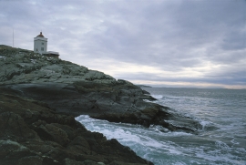
Hellisøy
Hellisøy lighthouse was lit for the first time in 1855. The characteristic red cast-iron tower with two white belts is 33m high and a light height of 46m above high tide.

Kræmmerholmen
Kræmmerholmen is one of the old privileged trading posts. From the 1600s all trading in West Norway took place in Bergen, and the farmers were obliged to travel into town in order to sell their produce and buy what they needed. In Bergen City Privilege of 1702 the merchants in the city were allowed to establish “Trading posts in the countryside”. The owner had to have residency in Bergen and the trading post was to be run by an assistant. In this way the city retained financial control of those living in the districts, and not least with buying and selling of fish.

Einstapevoll- the farm
Einstapevoll (from einstape: “bregne” (fern)) lies on the west side of the Tittelsnes peninsula. Up to 1831 the farm was a vicarage belonging to Stord parish. The priests had leasing rights. Land rent and other fees from the farm was part of their salaries.

Haugsbø
The single unit farm without a road to it, Haugsbø, is situated on the east side of the Tittelsnes peninsula facing Ålfjorden. As far back as the Middle Ages the farm has probably belonged to Stord Parish, up to the 1800s. In 1590 it was thought to be abandoned, but in 1601 Mickel Hougsbøe paid a tithe on the farm.
Ryvarden
In the Islandic Landnåmabok there is a story that the explorer Floke Vilgjerdsson built a cairn “where meetest Hordaland and Rogaland” and the cairn was named Flokavarði. Tormod Torfæus wrote in Historia Norvegica (1711) that this name was still in use, but that the farmers used “Ryvarden” for the same place.


