- Remove Middle age filter Middle age
- Remove Maritime environments filter Maritime environments
- Remove Civil servant dwellings and manors filter Civil servant dwellings and manors
- Remove Stord filter Stord
- Remove Place filter Place
- Remove Sawmills filter Sawmills
- Remove Plants by the sea filter Plants by the sea
- Remove Lakes, rivers and river networks filter Lakes, rivers and river networks
- Remove Large landforms filter Large landforms


Ådlandsstova
The Ådland house is one of the biggest medieval houses still existing in West Norway. It is constructed from unusually large, hard fir wood, beautifully oval-cut. One story links the cottage to the Gildeskålbakken at Orninggård (Lower Ådland); thus indicating that the cottage has been the medieval banqueting hall. The building has been dated back to the 13-1400s by carbon dating.


Huglo
The majority of Huglo is bare rock. A bit of dwarf pine forest is the only vegetation able to put down roots. Along the west- and east sides, to the contrary, the landscape is unusually green and lush. The reason lies both in the bedrock and in the ice that covered the area 12 000 years ago.

Ådlandsvatnet
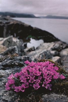
Plants that grow in and beside water have to be prepared for marked and rapid changes in their living conditions. They must be able to tolerate living under water without drowning, and getting totally dried out without whithering. Many swamp plants are well adapted to these kinds of changes.

Kattnakken–Stovegolvet
The highest mountainous area on Stord, including Kattnakken, Midtfjellet and Stovegolvet, has more in common with the mountainous terrain on the mainland than in the low coastal landscape of Sunnhordland. The volcanic bedrock together with the erosive powers of nature has resulted in a unique plateau landscape.
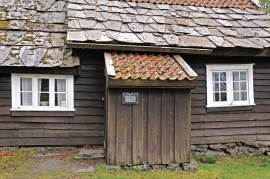
Sørhuglo
The tax collector’s farm at Sørhuglo is one of the many farms for state employees in Hordaland. According to history, “Futastovo” was built by the tax collector Gram in the second half of the 17th century. In 1943 the building was moved to Sunnhordland Folk Museum.

Sagvåg
The pit saw on the property of the farm Valvatna, is the origin of the name Sagvåg. The sawmill is mentioned as early as 1564. The name of the place at that time was Fuglesalt, but soon there is only talk of Saugvog.

