- Remove Middle age filter Middle age
- Remove Defense filter Defense
- Remove Os, frå 2020 del av nye Bjørnafjorden kommune filter Os, frå 2020 del av nye Bjørnafjorden kommune
- Remove Askøy filter Askøy
- Remove Tysnes filter Tysnes
- Remove Sediments filter Sediments
- Remove Fedje filter Fedje
- Remove Masfjorden filter Masfjorden
- Remove Deciduous forests filter Deciduous forests

Herdla – glacial deposits
The shift in the landscape is striking between the barren craggy moors north on Askøy and the green fields of Herdla, which has the county's biggest farm. The majority of Herdla, such as the island appears today, is a gift from the glacier: The glacier that advanced here over 12,000 years ago stopped at the northern tip of Askøy and took its time building up the moraine on Herdla. Since then, Herdla has been under continual transformation. The re-organisation of the loose sediment deposits continues today.

Herdla farm
Numerous finds show that the settlement at Herdla goes back to prehistoric times, and the large estate at Herdla has enjoyed a central place in the nation’s history since High Middle Ages. As Ask, Herdla was part of the country estate Harald Hårfagre took over as he took command of the west of Norway.
Ramsøy
“At thick of night a thundering knock on the door; the man in the house wakes up, jumps out and demands: Who cries? Yes, now you must out, the beacon shines on Høgenut. And in the same breath, every man knew that strife had hit the land.”

Vinappen
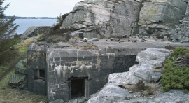
Vinappen lies on a low hill to the very west on the island. Here you have an amazing panorama of the sea. Originally the area was grazing land for cattle, but this changed when the Germans occupied the island. Just before WWII there was a small bearing station, used by the Norwegian Coast Artillery in connection with exercises at sea.


Matrehola
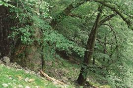
On a large gravel terrace in Matredalen (the Matre valley), a couple of kilometres from the coastal settlement Matre, lies Storseterhilleren, at the end of a large stone block that came rushing down from the mountain. The Matre river runs just over 100 metres to the east of the cave.


