- Remove Middle age filter Middle age
- Remove Granvin, frå 2020 del av nye Voss herad filter Granvin, frå 2020 del av nye Voss herad
- Remove Maritime environments filter Maritime environments
- Remove Hardanger og Voss filter Hardanger og Voss
- Remove Boat- and shipyards filter Boat- and shipyards
- Remove Kvam filter Kvam
- Remove Runestones filter Runestones
- Remove Stone age filter Stone age
- Remove Thrust sheets filter Thrust sheets
- Remove Ulvik filter Ulvik
- Remove Jondal, frå 2020 del av nye Ullensvang kommune. filter Jondal, frå 2020 del av nye Ullensvang kommune.

Øvre Folkedal
Folkedal, which today is like a small “detour” from the main highway, was in the Middle Ages centrally situated in one of the most important roads between Hardanger and Voss. This is the road that Olav Haraldsson travelled in 1023, when he came from the royal farm at Avaldsnes for a meeting with the Voss inhabitants about the new belief. The road passes across the mountain pasture Krossaset and down Bordalen to Vangen.

Vesoldo
Folds are to be found everywhere in the remains of the Caledonian mountain chain. Some were formed during the collision with Greenland, others stem from the time when the mountain chain collapsed. Few can compare with the giant fold that remains in the mountain area around Tørvikenuten, Vesoldo and Hellefjellet.
Vangdal
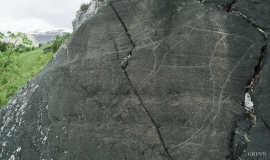
At Salthamaren in Vangdalsberget it is thought that salt was burned some time in history, and deep layers of coal in the ground show that fire has been made up here several times. But they were hardly salt-burners, the first people who stopped here. Some of them carved figures into the rock. On top of the rocky outcrop, furthest out on the cliff, a group of Stone Age hunters carved animal figures. More than 1,500 years later Bronze Age farmers drew ship figures at the foot of the rock. Both these works of art - some of the oldest in Hordaland – are still visible, carved in the rock at Salthamaren.

Sålesnes
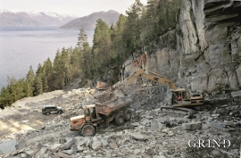
Jondal has one of the country’s oldest slate quarries. Roof tiles have been extracted here since the end of the 1700s, but the quarry is much older. Kvernurdi is mentioned in a diploma in 1421, when Bård Sigurdsson at Torsnes became the owner through a settlement. Already then it must have been customary to cut millstones here.

Svåsand
Down by the fjord at Svåsand, close to the main highway, there is a long row of boathouses, one of the well-preserved, older boathouse locations along the Hardanger fjord. It is the farms at Svåsand that have their boathouses here, four main farms with origins far back in time.

Rallarvegen
They rest there, all as one, the silent witnesses of Western Norway's saga of creation: Precambrian basement, phyllite and thrust sheet. In the end came the glaciers and sculptured the vast landscape. Along the ground or on the horizon, from bicycle or on foot - the landscape tells its story - and it tells it clearer on Rallarvegen than many other places.

Lussand- geology
Hardangerfjorden kløyver Hordaland i to. Den etter måten rettlinja fjorden skjer seg liksom på skeive inn i landet. Ikkje som Sognefjorden og Nordfjord – dei krokar og buktar seg innover meir eller mindre vinkelrett på kysten. Hardangerfjordens utforming har røter 400 millionar år tilbake i tida, då den veike sona i fjellet, der isen seinare tok grådig for seg, vart danna. Denne sona stig på land ved Lussand.

