- Remove Maritime environments filter Maritime environments
- Remove Place filter Place
- Remove Trading posts and guesthouses filter Trading posts and guesthouses
- Remove Vaksdal filter Vaksdal
- Remove Modalen filter Modalen
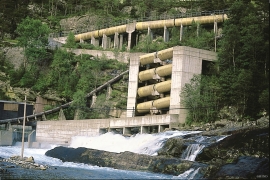
- Remove Avalanches and rock falls filter Avalanches and rock falls
- Remove Stord filter Stord
- Remove Fish filter Fish
- Remove Large landforms filter Large landforms

Nedre Helland- skred
Many still remember when the avalanche struck Nedre Helland, on the 14th of August, 1953 14:30 o'clock. All of the buildings at one of the farms and the main house on the neighbouring farm were destroyed. The one woman who was inside a building escaped, frightened but unharmed. The same with the others who lived at Nedre Helland; everyone was a safe distance from the avalanche.

Otterstad
Tthe Otterstad farms lie in the innermost part of Mofjorden, on the northwest side of the river. The row of stave-built boatsheds that belong to the farm were probably constructed a little after the middle of the 1800s. Both here and on the Mo side, the boatsheds were important storage places at the seashore; wood and other farm products intended for the town; corn and merchandise in return.


Bergsdalen
The mountains of western Norway are lovely to wander in. In Cambro-Silurian time it was the mountain itself that wandered. The mountain, or more correctly the bedrock, first moved eastward, then back a bit westward again. All this rocking back and forth in the mountains ended about 400 million years ago.

Eksingedalen- landscape
Eksingedalen alternates between wide, flat flood plains with good farmland, and narrow passages with waterfalls where the roads cling to the mountainsides. The alternations in the landscape are a result of the sculpturing work by glaciers over several ice ages, and the deposition of the glacial river deposits when the last glacier finally melted back.


Huglo
The majority of Huglo is bare rock. A bit of dwarf pine forest is the only vegetation able to put down roots. Along the west- and east sides, to the contrary, the landscape is unusually green and lush. The reason lies both in the bedrock and in the ice that covered the area 12 000 years ago.

Kattnakken–Stovegolvet
The highest mountainous area on Stord, including Kattnakken, Midtfjellet and Stovegolvet, has more in common with the mountainous terrain on the mainland than in the low coastal landscape of Sunnhordland. The volcanic bedrock together with the erosive powers of nature has resulted in a unique plateau landscape.

Leirvik- The trading post
Already in the Middle Ages the good harbour at Leirvik provided a connecting point. Here was a court of law, and a guesthouse was established here in the 1600s. But Leirvik never achieved the status of a trading post or a ship-loading place. In the census of 1865 parts of the farms Nordre Bjelland, Leirvik and Orninggård are mentioned as the “Coastal district of Lervig”. And the community grew around the old guesthouse location early in the 1800s.

