- Remove Maritime environments filter Maritime environments
- Remove Avalanches and rock falls filter Avalanches and rock falls
- Remove Churches filter Churches
- Remove Eidfjord filter Eidfjord
- Remove Late glacial filter Late glacial
- Remove Radøy, frå 2020 del av nye Alver kommune. filter Radøy, frå 2020 del av nye Alver kommune.
- Remove Fusa, frå 2020 ein del av nye Bjørnafjorden kommune filter Fusa, frå 2020 ein del av nye Bjørnafjorden kommune
- Remove Waterfalls filter Waterfalls
- Remove Glaciers filter Glaciers

Eidfjord church
The old stone church at Eidfjord has an open position on the terrace at Lægreid. In a diploma from 1310 it transpires that Torgeir on Sponheim donated a gift for the erection of the church in Eidfjord. Thus we can assume that the church was under construction at the time. The elements in the style confirm such a dating.

Fruo
At Fruo, nature has built its own little "Chinese wall ". Some kilometers south of the Vøringsfossen waterfall, there are a number of moraine ridges, the longest and most notable of their kind in Hordaland.

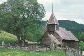
Holdhus church
The old church at Holdhus is one of the oldest timbered churches left in the west of Norway. The new church at Eide, built in 1889, replaced the church location from the Middle Ages. As the small, tarred church lies today, in the hilly landscape at Holdhus, it was taken over by the Society for the Preservation of Norwegian Ancient Monuments, who obtained title to the property in 1900 from Hans Holdhus.

Hæreid- geology
The Eidfjord terrace is a gigantic ridge that reaches up more than one hundred metres from the city centre in Eidfjord. It serves as a powerful natural monument left behind by the ice when it retreated.


Måbødalen- geology
The old pack road had 1500 steps, where cars today gas through the mountain. The time of this hard work is over, and of getting used to the steep terrain, as well; only the view from the top is much the same as before. Vøringsfossen in summer is one of Western Norway’s biggest natural wonders. It marks the transition between the older, open part of the Sysendalen valley and the younger, narrow and winding valley of Måbødalen.


Simadalen
On the 10th of August, 1937, over half of the agricultural land in Simadalen was submerged by the river. The damage to roads and houses was also catastrophic. This was the most destructive flood ever recorded in Hordaland.

Skjelbreid
On the east side of Lake Skjelbreidvatnet, clearly visible along the road from Eikelandsosen, we notice a farm on a terrace above a grassy hill. The hill has the form of a broad shield; Skjelbreid (" Broad Shield") is the name of the farm.

