- Remove Maritime environments filter Maritime environments
- Remove Askøy filter Askøy
- Remove Os, frå 2020 del av nye Bjørnafjorden kommune filter Os, frå 2020 del av nye Bjørnafjorden kommune
- Remove Civil servant dwellings and manors filter Civil servant dwellings and manors
- Remove Stord filter Stord
- Remove Archaeological findings filter Archaeological findings
- Remove Large landforms filter Large landforms
- Remove Fitjar filter Fitjar
- Remove Masfjorden filter Masfjorden

Herdla farm
Numerous finds show that the settlement at Herdla goes back to prehistoric times, and the large estate at Herdla has enjoyed a central place in the nation’s history since High Middle Ages. As Ask, Herdla was part of the country estate Harald Hårfagre took over as he took command of the west of Norway.
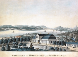
Hop- Thomas Erichsens Minde
From the 1500s Hop was noble estate for the law speaker in Bergen and Gulen judicial districts. Several of the law speakers were of noble descent, such as Hans Hansen Lillienskiold and Niels Knagenhielm. The beautiful main building, still standing, was erected by the Bergen merchant Thomas Erichsen in 1793-95. He also established a magnificent garden with an 800 metres long linden avenue reaching down to the stone boathouse at Hop harbour.


Dyrdal
If you journey along Austfjorden, you at the same time turn the pages of time back through Ice Age history. The landforms show how the landscape has developed gradually as the glaciers have grown - and melted again - in several episodes: from small cirques, we see innermost at Dyrdal, to larger fjords, like at Mas fjord further out.

Matrehola
On a large gravel terrace in Matredalen (the Matre valley), a couple of kilometres from the coastal settlement Matre, lies Storseterhilleren, at the end of a large stone block that came rushing down from the mountain. The Matre river runs just over 100 metres to the east of the cave.


Fitjar- the King's farm
In front of Fitjar Church there is a memorial stone, sculpted by Anne Grimdalen and erected in 1961, for the thousand-year memorial of one of the most dramatic events in Norway’s history, the Battle of Fitjar. This was the place where Norway’s king, Håkon the Good, suffered his fatal injury in the fight with Eirik’s sons, probably in the year 961.

Fitjarøyane
If we study the group of islands south of Selbjørns Fjord from the air or on a sea map, we will notice that many of the islands are elongated and lie systematically in rows. The islands are divided by long sounds, for example Trollosen, Nuleia and Hjelmosen, which are oriented in a south-southeast to north-northwesterly direction.

