- Remove Maritime environments filter Maritime environments
- Remove Austrheim filter Austrheim
- Remove Nordhordland filter Nordhordland
- Remove Place filter Place
- Remove Factories filter Factories
- Remove Farm sites filter Farm sites
- Remove Quarns and mills filter Quarns and mills
- Remove Lindås, frå 2020 del av nye Alver kommune. filter Lindås, frå 2020 del av nye Alver kommune.
- Remove Benthic organisms filter Benthic organisms
- Remove Wetland filter Wetland


Hopland
The farmhouses at holding No. 15 at Hopland are built together to form a long, continuous building, with dwelling house, hayshed and cowshed built in one row. There have been many such joined structures in the coastal communities, but today there are few remaining. If we travel to the other side of the North Sea, to the Faeroes, Shetland and the Orkney Islands, we find corresponding features in the older building traditions. We find ourselves in a large North Atlantic cultural area.

Krossøy
Furthest north in the island community Rongevær, at the entrance to Fensfjorden, lies Krossøy. Belonging to the farm are the islands of Krossøy, Husøy, Kårøy, Lyngkjerringa, Søre Kjerringa, Rotøy and Kuhovet. All of them have been inhabited. On Krossøy itself today there are four holdings. The marine use environment here is one of the best preserved along the West Norwegian coast.


Leirvågen
A marsh is a grassy meadow that is strongly influenced by salt from the sea. This type of nature is abundant in Denmark, among other places. The flatlands along the river that run out by Leirvågen, are the municipalities' largest marsh. At spring tide, these flatlands are flooded underwater for several hundred metres in over land.


Bjørsvik
The industrial settlement Bjørsvik
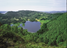
Fossevatna
Fossevatna, some few kilometres north of Alversund, is one of the finest wetland areas in Lindås. Especially the birdlife has made this place well known. Throughout the year, one can make exciting bird discoveries. But, if you want to hear the flight games skal høre med fagredaktør Stein Byrkjeland of the Snipe, you should come here on a spring or summer evening.
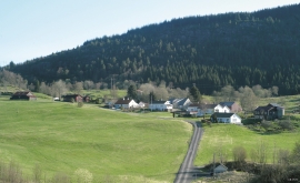
Isdal
Isdal one of the few clustered settlements left in the Hordaland communities, after the extensive changes taking place around the turn of the former century, which broke up the shared farms and the old intermixture of strips. The old, low houses are situated in a compact enclosure, which is very noticeable in the landscape when you travel the main road north from Knarrvik.

