6 results
- Remove Maritime environments filter Maritime environments
- Remove Nordhordland filter Nordhordland
- Remove Vaksdal filter Vaksdal
- Remove Factories filter Factories
- Remove Modalen filter Modalen
- Remove Fedje filter Fedje
- Remove Lindås, frå 2020 del av nye Alver kommune. filter Lindås, frå 2020 del av nye Alver kommune.
- Remove Arkitektur filter Arkitektur
- Remove Railroad filter Railroad

Otterstad
30.03.2018 - 19:53
Tthe Otterstad farms lie in the innermost part of Mofjorden, on the northwest side of the river. The row of stave-built boatsheds that belong to the farm were probably constructed a little after the middle of the 1800s. Both here and on the Mo side, the boatsheds were important storage places at the seashore; wood and other farm products intended for the town; corn and merchandise in return.
Last changed: 30.03.2018 | Content type: Place
Stormark
07.12.2018 - 13:22
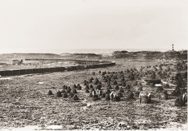
Both the climate and people have been decisive in shaping the bog landscape on Fedje - a landscape that has been evolving over several thousands of years. The peat got built up layer for layer and provided income and fuel for the people of Fedje.
Last changed: 07.12.2018 | Content type: Place

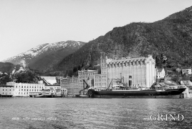
Bjørsvik
24.06.2018 - 15:41
The industrial settlement Bjørsvik
Last changed: 24.06.2018 | Content type: Place