- Remove Boats and seafaring filter Boats and seafaring
- Remove Late glacial filter Late glacial
- Remove Sedimentary rocks filter Sedimentary rocks
- Remove Kvinnherad filter Kvinnherad
- Remove Bergen filter Bergen
- Remove Farm sites filter Farm sites
- Remove Osterøy filter Osterøy
- Remove Defense filter Defense

Arnatveit
On the farm of Arnatveit, high up on the slope above the highway, an old smokehouse remains standing in the courtyard of the main farm property, in the place of the old common courtyard. Today this farm lies at the outskirts of a large housing estate. Most of the farmland of the other farm properties has been sold to benefit the city’s need of sites for the new community of Arna.


Bondhusdalen
The Bondhus area in Maruanger has been a magnet for tourists ever since the stream of tourists to Norway's west coast began in the middle of the 1800s. The magnificent landscape with the "ice trail" up to Bondhusvatnet Lake, the ice falls from Bondhusbreen glacier and Keisarstigen trail up to Folgefonna are still popular tourist attractions.

Halsnøy
Hadde ikkje Hardangerfjordbreen mot slutten av istida rykt fram over fjordbotnen, ville Halsnøy ikkje eksistert som éi øy, men som mange småøyar. Breen skuva framfor seg så mykje leire frå havbotnen at Brattåsen, Toftåsen, Landåsen og Svartaberg vart samla i eitt landområde.

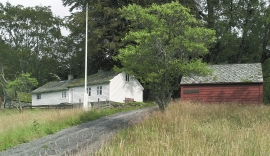
Havrå
In the sunny, steep fjord landscape along Sørfjorden on the east side of Osterøy is the farm Havrå. The small “hamlet” is one of the few undisturbed farming communities that gives us the impression of the large communal yards in West Norway in the 1700s, with houses built close together and strips of arable land.


Melderskin
MELDERSKIN - ONCE A NUNATAK? Melderskin, the towering and majestic landmark at Rosendal, rises 1462 metres above sea level. The top area is smooth, but slightly inclined. Geologists think that the area is a remnant of a weakly undulating landscape, that originated near the sea, long before the Ice Age set in.
Rød
In 1969 Sigurd and Margreta Dønhaug donated a collection of around 170 historical cultural objects to Kvinnherad municipality. They wanted their gift to become the start of a farm collection in Uskedalen. And that is what happened.

Sandviksfjellet
On Sandviksfjellet there are old boulders that have been made into mountains. The stones have been stretched out or squeezed together between huge slabs of rock, during slow, but powerfulprocesses of transport. This conglomerate shows, in quite a special way, the enormous powers that were active during the collision between Norway and Greenland over 400 million years ago.

