- Remove Quarns and mills filter Quarns and mills
- Remove Benthic organisms filter Benthic organisms
- Remove Nordhordland filter Nordhordland
- Remove Smallholdings filter Smallholdings
- Remove Middle age filter Middle age
- Remove Vernacular crafts filter Vernacular crafts
- Remove Defense filter Defense
- Remove Thrust sheets filter Thrust sheets


Vinappen
Vinappen lies on a low hill to the very west on the island. Here you have an amazing panorama of the sea. Originally the area was grazing land for cattle, but this changed when the Germans occupied the island. Just before WWII there was a small bearing station, used by the Norwegian Coast Artillery in connection with exercises at sea.

Bjørsvik
The industrial settlement Bjørsvik
Lure Fjord
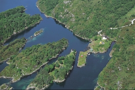
Both Lure Fjord and Lindåsosane to the inside give good living conditions for rare marine organisms: jellyfish, shellfish and fish. These include animals that migrated in after last the Ice Age, when the sea level was higher. Eventually, as the land rose, some of these populations became isolated.

Lurekalven
Lurekalven is an unpopulated island of heather moor which is a part of the wilderness belonging to the five farms on Ytre Lygra. Between the two islands there is only a small sound. As late as the 1920s, milking cows were rowed over the sound from Lygra in summer – a form of farming that was adapted to the coastal landscape.


Matrehola
On a large gravel terrace in Matredalen (the Matre valley), a couple of kilometres from the coastal settlement Matre, lies Storseterhilleren, at the end of a large stone block that came rushing down from the mountain. The Matre river runs just over 100 metres to the east of the cave.


Eldsfjellet
The eclogites in western Norway were formed when Precambrian basement rocks were squeezed and pressed down under great pressure deep under the Caledonian mountain chain. The process may well have triggered some of the deepest earthquakes the world has ever known. The clearest traces of this drama are found in and around Mt. Eldsfjellet, in peaceful Meland.

