- Remove Quarns and mills filter Quarns and mills
- Remove Trading posts and guesthouses filter Trading posts and guesthouses
- Remove Sediments filter Sediments
- Remove Railroad filter Railroad
- Remove Thrust sheets filter Thrust sheets
- Remove Faults filter Faults
- Remove Sund, frå 2020 del av nye Øygarden kommune filter Sund, frå 2020 del av nye Øygarden kommune
- Remove Ulvik filter Ulvik

Bergensbanen
Already at the beginning of the 1870s demands were made that there had to be a railway connection between Bergen and East Norway. The first section between Bergen and Voss was finished in 1883. The route alternatives further on were many: Lærdal-Valdres, Aurland-Geiteryggen, Raundalen-Finse and Ulvik-Finse. Following a long dispute, an agreement was finally reached that the middle route alternative, Raundalen- Myrdal- Finse, was the best alternative. In 1894 the government passed a resolution that the Bergen railway should be built, but only the section Voss-Taugevatn. This was a political gamble in order to make the rest of the country participate in the plans. In 1898 it was approved that the railway be continued eastwards from Taugevatn to Oslo. This high mountain project was one of the most challenging railway projects in Europe. The Bergen railway was to be built across a mountain plateau without roads.

Bergensbanen- snow measurements
Opponents of the Bergen Railway used the snow argument for all it was worth. During the debate in Parliament before the decision about the route was reached in 1894, fears of snowfalls of over 20 metres were presented.

Rallarvegen
They rest there, all as one, the silent witnesses of Western Norway's saga of creation: Precambrian basement, phyllite and thrust sheet. In the end came the glaciers and sculptured the vast landscape. Along the ground or on the horizon, from bicycle or on foot - the landscape tells its story - and it tells it clearer on Rallarvegen than many other places.

Ulvik-village
The ice cap that covered the land during each of the 40 past ice ages over the past 2 million years of Earth's history pressed down the crust of the earth - like a finger on a rubber ball. And when the ice finally loosened its grip 11,000 years ago, the earth's crust rose again, most where the ice was thickest, least where it was thin, quickly in the beginning, and later more slowly. To this day, the land in the inner part of Norway continues to rise by perhaps one millimetre per year. By and large, however, the crust in Hordaland has again reached equilibrium after the weight of the ice was removed.
Bukken
In Christian IV’s diary from Norgesreisa (trip to Norway) in 1599, we find the reference or anecdote that is the origin of the name Bukken. A Dutch full-rigged ship once passed the mountain outcrops on the island with the guesthouse so close that a ram grazing there jumped down on a yardarm (rånokk), thus the name “Buch van Raa!”
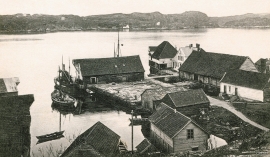
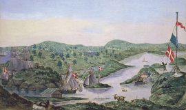
Glesvær- Trading post
Glesvær is one of the oldest trading posts on the West Norwegian coast. In the 1700s and 1800s this was the most important fishing centre on Sotra. The first certain mention of the trading station Glesvær is in 1664. At that time it was the Bergen merchant Hendrich Wessel who owned the place and was in the possession of a trading privilege. Abraham Wessel, who took over in 1688 also obtained Royal Privilege for “Kiøbmandskab med Bønderne alleene at drive” (the only one to be allowed to carry on trade with the farmers).

