- Remove Quarns and mills filter Quarns and mills
- Remove Mineral resources filter Mineral resources
- Remove Tourism filter Tourism
- Remove Bedrock filter Bedrock
- Remove Settlements, Villages, Towns filter Settlements, Villages, Towns
- Remove Mines filter Mines
- Remove Thrust sheets filter Thrust sheets
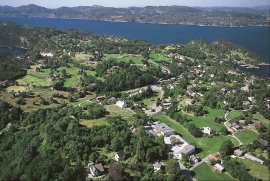
Ask- jordbær
Strawberry-growing on Askøy flourished in the beginning of the last century. When gardener Samson Eik took in the type "Seierherren" from Rosendal in 1909 for growing strawberries on Hop, it appeared that the soil and climate in this area was perfect for the mass production of strawberries.


Bergsdalen
The mountains of western Norway are lovely to wander in. In Cambro-Silurian time it was the mountain itself that wandered. The mountain, or more correctly the bedrock, first moved eastward, then back a bit westward again. All this rocking back and forth in the mountains ended about 400 million years ago.

Eldsfjellet
The eclogites in western Norway were formed when Precambrian basement rocks were squeezed and pressed down under great pressure deep under the Caledonian mountain chain. The process may well have triggered some of the deepest earthquakes the world has ever known. The clearest traces of this drama are found in and around Mt. Eldsfjellet, in peaceful Meland.


Godøysund
The old hostelry centres were strategically placed with good harbours and anchoring conditions where people travelled. GODØYSUND, or Gøysundet, as it was called, was in the middle of Tysnes Parish, with easy access from the sea, also for the local population. Gøysundet is amongst the oldest hostelries in Sunnhordland.

Gullbotnen
A barren belt where almost nothing grows, runs through the forest on the east slope of Gullbotnen. But, along the west side of the main road there is a fertile zone that flourishes with several finicky plant types. The contrasts arise from the extreme variations in the nutrient content of the bedrock.

