- Remove Quarns and mills filter Quarns and mills
- Remove Øygarden, frå 2020 del av nye Øygarden kommune. filter Øygarden, frå 2020 del av nye Øygarden kommune.
- Remove Voss, frå 2020 del av nye Voss herad. filter Voss, frå 2020 del av nye Voss herad.
- Remove Bergen filter Bergen
- Remove Maritime environments filter Maritime environments
- Remove Sedimentary rocks filter Sedimentary rocks
- Remove Fedje filter Fedje

Sandviken
Close to the tunnel opening at Amalie Skrams vei in Ssandviken, there is a cultural monument of European dimensions; a rope making works that produced rope and fishing tackle for West and North Norway.

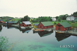
Hjelmo
On the farm Hjelmo, furthest north in Øygarden, in the innermost part of a long bay, there is a fine boatshed collection with a church beside it. From times immemorial this has probably been the fish-shed location for these farm units and this was also the landing place for the churchgoers.

Rekvemylna
If you enter the farmyard at Rekve, some kilometres from Bulken, where the road departs to Giljarhus, you no longer meet “the miller”, Knut Hernes, in his old rural mill. But some years ago he would wish you welcome, friendly and hospitable, and show you around his mill, which had been his workplace for a generation. As light-footed as a youth he climbed in steep ladders high up into the waterfall, to let the water down on to the waterwheel.
Herdlevær
Herdlevær lies on one of the small islands west of Hjeltefjorden, facing the North Sea and the big ocean. Today you may arrive there by car. The numerous islands are linked together by elegant bridge spans made of concrete. Fifty years ago it was half a day’s journey to get to Herdlevær from the mainland by your own rowing boat or ferry.


Kvernapollen
When the workers came to Kollsnes to start on the work with the landing for the gas terminal from the Troll field in the North Sea, they found the ruins of an old farm mill at Kvernapollen.

Holmengrå
Holmengrå is the only place in Hordaland where we find traces of the abrasion that is supposed to have transformed Western Norway from a Himalaya-like high mountain landscape during the earth's Paleozoic Era, to a flat lowlands terrain during the Mezosoic Era. Just 400 million years ago, large and small stones plummeted down from the high mountains. Some of these stones became incorporated into the conglomerate bedrock on Holmengrå.

Sandviksfjellet
On Sandviksfjellet there are old boulders that have been made into mountains. The stones have been stretched out or squeezed together between huge slabs of rock, during slow, but powerfulprocesses of transport. This conglomerate shows, in quite a special way, the enormous powers that were active during the collision between Norway and Greenland over 400 million years ago.

