- Remove Quarns and mills filter Quarns and mills
- Remove Voss (tidl. kommune) filter Voss (tidl. kommune)
- Remove Hill forts filter Hill forts
- Remove Sunnhordland filter Sunnhordland
- Remove Sediments filter Sediments
- Remove Basement rocks filter Basement rocks
- Remove Museum filter Museum

Rosendal Barony
The Barony of Rosendal lies in the grounds of the old noble estate of Hatteberg, on the north side of the Hatteberg river, around one kilometre up from the sea. The three noble estates Seim, Mel and Hatteberg constituted the core of the large estate taken over by Ludvig Rosenkrantz in 1662, after he was married to Karen Mowat in 1658.
Rød
In 1969 Sigurd and Margreta Dønhaug donated a collection of around 170 historical cultural objects to Kvinnherad municipality. They wanted their gift to become the start of a farm collection in Uskedalen. And that is what happened.

Borgåsen
In Etne there are no less than four defensive refuges. They are all situated in strategic positions, so that they have served as places of refuge and protection for central parts of the district

Årskog
Årskog farm is situated in a typical coastal landscape in a gentle terrain that slopes down from the outlying heaths down towards the fjord. The farm steading exists as it was in the 1800s. In 1980 the two brothers, Lars and Olai Årskog donated the farm with all its contents of tools and interior decoration, for museum purposes.
Litlabø
The first finds of pyrite at Litlabø in Stord came to light in 1864. Forty years later sulphuric ore was mined from an open mine. From 1874 to 1880 it was used for dynamite production. That came to a sudden end when the factory exploded and three people died.
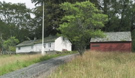
Sørhuglo
The tax collector’s farm at Sørhuglo is one of the many farms for state employees in Hordaland. According to history, “Futastovo” was built by the tax collector Gram in the second half of the 17th century. In 1943 the building was moved to Sunnhordland Folk Museum.


Rekvemylna
If you enter the farmyard at Rekve, some kilometres from Bulken, where the road departs to Giljarhus, you no longer meet “the miller”, Knut Hernes, in his old rural mill. But some years ago he would wish you welcome, friendly and hospitable, and show you around his mill, which had been his workplace for a generation. As light-footed as a youth he climbed in steep ladders high up into the waterfall, to let the water down on to the waterwheel.

Stalheim
Stalheim is situated between Stalheimsfossen and Sivlefossen, in a community with the farms Sivle and Brekke. The most likely explanation of the name is “the farm by Stadall”, from “standa” (stand), probably with background in the steep Stalheimskleivi. The farm has for a long time been divided into several units. At Stalheim there has been a transport exchange from the Middle Ages and the farm has been a postal farm since 1647.

Staup
The farm STAUP lies on a shelf in the terrain above Løno. From the highway E16 it is possible to glimpse the houses through the trees. The farm is without a road, and the old farmyard and the cultural landscape is very well preserved. In the 1980s grants were given to carry out maintenance work with the intention of protecting the houses in the farmyard.

