- Remove Smallholdings filter Smallholdings
- Remove Jondal, frå 2020 del av nye Ullensvang kommune. filter Jondal, frå 2020 del av nye Ullensvang kommune.
- Remove Maritime environments filter Maritime environments
- Remove Avalanches and rock falls filter Avalanches and rock falls
- Remove Eidfjord filter Eidfjord
- Remove Late glacial filter Late glacial
- Remove Austrheim filter Austrheim
- Remove Fisheries filter Fisheries
- Remove Basement rocks filter Basement rocks
- Remove Quarns and mills filter Quarns and mills
- Remove Samnanger filter Samnanger

Svåsand
Down by the fjord at Svåsand, close to the main highway, there is a long row of boathouses, one of the well-preserved, older boathouse locations along the Hardanger fjord. It is the farms at Svåsand that have their boathouses here, four main farms with origins far back in time.

Fruo
At Fruo, nature has built its own little "Chinese wall ". Some kilometers south of the Vøringsfossen waterfall, there are a number of moraine ridges, the longest and most notable of their kind in Hordaland.

Hæreid- geology
The Eidfjord terrace is a gigantic ridge that reaches up more than one hundred metres from the city centre in Eidfjord. It serves as a powerful natural monument left behind by the ice when it retreated.


Notaholmen
The fishnet shed at Notaholmen stands as a reminder of the days when people used to row out on the fjord to set their nets. On Notaholmen the nets were dried, repaired and tanned. And it was a great advantage to store them in a place inaccessible for rats and mice.

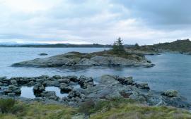
Krossøy
Furthest north in the island community Rongevær, at the entrance to Fensfjorden, lies Krossøy. Belonging to the farm are the islands of Krossøy, Husøy, Kårøy, Lyngkjerringa, Søre Kjerringa, Rotøy and Kuhovet. All of them have been inhabited. On Krossøy itself today there are four holdings. The marine use environment here is one of the best preserved along the West Norwegian coast.