- Remove Music filter Music
- Remove Hydro power filter Hydro power
- Remove Rock carvings filter Rock carvings
- Remove Road constructions filter Road constructions
- Remove Large landforms filter Large landforms
- Remove Voss, frå 2020 del av nye Voss herad. filter Voss, frå 2020 del av nye Voss herad.
- Remove Vaksdal filter Vaksdal

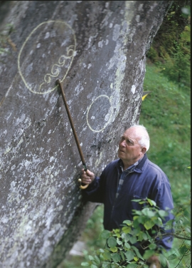
Bergsdalen
The mountains of western Norway are lovely to wander in. In Cambro-Silurian time it was the mountain itself that wandered. The mountain, or more correctly the bedrock, first moved eastward, then back a bit westward again. All this rocking back and forth in the mountains ended about 400 million years ago.

Dale power station
In 1923 Bergenshalvøens Kommunale Kraftselskap (BKK) expropriated large areas for power plants and development of hydropower started soon afterwards. Dale power station with the two first aggregates, each of 14 MW was put into operation on 17 November 1927. In the supply reservoir in Storefossen 5152 cubic metres of concrete were cast, and a modern and well-equipped power station was built.

Dalseid- Eidslandet road construction

Eksingedalen- hydropower development
Water discharge at the outlet of the Ekso into Eidsfjord was halved after the big hydropower development in the mountainous area between Modalen and Eksingedalen and further southward toward Evanger in the 1960s, 70s and 80s. In an attempt to amend the changed environmental conditions in the waterway the developer built 35 small dams in the river.

Eksingedalen- landscape
Eksingedalen alternates between wide, flat flood plains with good farmland, and narrow passages with waterfalls where the roads cling to the mountainsides. The alternations in the landscape are a result of the sculpturing work by glaciers over several ice ages, and the deposition of the glacial river deposits when the last glacier finally melted back.

Bolstad
The village at Bolstadøyri acquired its structure around the middle of the 1800s, but from the old days there has been a meeting place here; court location and trading post. The guesthouse place stems from the second half of the 17th century, and in the previous century Bolstadøyri was one of the largest rural trading posts in Nordhordland.


Hamlagrø
The type of underlying rock can be decisive for how many different types of plants are found in an area. In the area around Hamlagrø-lake the diversity is especially obvious. The geological conditions change much here within a short distance.
Ole Bull-akademiet
Sigbjørn Berhoft Osa and Ole Bull - Akademiet

