- Remove Basement rocks filter Basement rocks
- Remove Midthordland filter Midthordland
- Remove Hydro power filter Hydro power
- Remove Place filter Place
- Remove Maritime environments filter Maritime environments
- Remove Boat- and shipyards filter Boat- and shipyards
- Remove Fisheries filter Fisheries
- Remove Sunnhordland filter Sunnhordland

Ingahogg
At nearly 1000 metres over sea level, on the north side of INGAHOGG mountain, the remains of a soapstone quarry have been discovered. It is said, according to the Sagas, that Inga collected the big soapstone that lies in front of the Åkra Church from here.

Ulvanosa
Some mountains have rounded shapes, while others have steep slopes and sharp edges. Ulvanosa (1246 mos.) has both. The forms reflect the type of bedrock below, and the forces that were in effect when they were formed.


Haganes
The gneiss landscape west and north of Bergen viewed in profile can remind us of a saw blade of the kind that has long, slanted sides that get broken off shorter transverse sides. It has taken several hundred million years to file this saw blade, an enduring interplay between various geological processes.

Frøland
Much rain, a steep drop and nearness to Bergen meant that the power-making potential of the Samnanger water system was exploited early. Samnanger was thus one of the first power-producing municipalities in western Norway. With its subsequent expansion and new power stations, about 400 gigawatts of electricity per hour were produced on average each year. This is enough to meet the energy needs of 25,000 households.

Golta- Gneiss
Over thousands of years, autumn storms and strong land-driving winds have cleaned the bare rocks of Golta. The waves can beat far in over land and make it dangerous to walk along the shoreline. When the storms have calmed, the results of their work comes into view.

Goltasundet
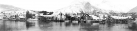
For generations the land-seine was the most important tool for catching herring and mackerel, and therefore a suitable casting bay was worth its weight in gold. Goltasundet (the Golta sound) on Golta was such a place. Here the herring often drifted in and fantastic casts might be made here.


