- Remove Boat- and shipyards filter Boat- and shipyards
- Remove Basement rocks filter Basement rocks
- Remove Nordhordland filter Nordhordland
- Remove Vernacular crafts filter Vernacular crafts
- Remove Currents and tides filter Currents and tides
- Remove Middle age filter Middle age
- Remove Cultural landscapes filter Cultural landscapes
- Remove Sunnhordland filter Sunnhordland


Halsnøy Monastery
Halsnøy Monastery is situated in the midst of the lush fjord country in Sunnhordland, on one of the old spits, or “necks”, that has given name to the island. Gently sloping fields lead down to the sea on both sides, in the south towards the Kloster Fjord, to the north towards the sheltered Klostervågen.

Ingahogg
At nearly 1000 metres over sea level, on the north side of INGAHOGG mountain, the remains of a soapstone quarry have been discovered. It is said, according to the Sagas, that Inga collected the big soapstone that lies in front of the Åkra Church from here.
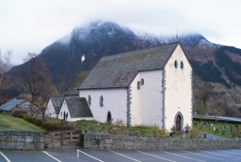
Kvinnherad Church
The stately Kvinnherad Church with its characteristic profile set out against the mighty Malmangernuten in the background, gives you a rare feeling of being present in a historic landscape as you come around Nes and face the well-kept houses at the Skåla farm. The church at Skåla is one of four “fjordungskirker” (one of four main district churches) and this farm was the centre of this coastal administration district.
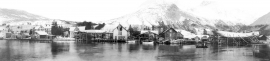
Sunde
In 1852 Haktor Thorsen erected two large warehouses on one of his farms in Sunde and started trading and salting herring. This was the start of an industrial adventure that made Sunde into one of the first industrial communities in Kvinnherad.

Ulvanosa
Some mountains have rounded shapes, while others have steep slopes and sharp edges. Ulvanosa (1246 mos.) has both. The forms reflect the type of bedrock below, and the forces that were in effect when they were formed.


Lurekalven
Lurekalven is an unpopulated island of heather moor which is a part of the wilderness belonging to the five farms on Ytre Lygra. Between the two islands there is only a small sound. As late as the 1920s, milking cows were rowed over the sound from Lygra in summer – a form of farming that was adapted to the coastal landscape.

Lygra
The heath landscape on outer Lygra, Utluro and Lurekalven will in future become part of a landscape protection area, to be maintained through traditional activities with year-round outdoor sheep, grazing and burning. The West Norwegian heath country belongs to a large North Atlantic coastal landscape stretching from the Bay of Biscay to the Lofoten islands.

