- Remove Small landforms filter Small landforms
- Remove Seabirds filter Seabirds
- Remove Monastery filter Monastery
- Remove Fitjar filter Fitjar
- Remove Ullensvang, frå 2020 del av nye Ullensvang kommune. filter Ullensvang, frå 2020 del av nye Ullensvang kommune.
- Remove Bømlo filter Bømlo
- Remove Igneous rocks filter Igneous rocks
- Remove Coniferous forests filter Coniferous forests
- Remove Kvam filter Kvam
- Remove Fisheries filter Fisheries


Espevær- the Trading Post
In the sea west of Bømlo lies Espevær, half an hour’s rowing trip across the sound from Vespestadvågen. This is a well-run and well-maintained local community, established on the back of the rich herring fisheries in the 1850s. It is fishermen, skippers and the tradesmen who have made their mark on the culture in Espevær, with their contacts to the south towards Haugesund and across the North Sea to the British Isles.


Hisøya
"I am going to prove to you that I am right". That is what the idealist and county doctor Christian Heitmann is supposed to have said in the early 1890s. He sat together with the parish priest, Kullmann, at Heitmann's home in Stord and discussed whether the islands in western Norway could have been forested or not. The priest thought that the area was too barren and weather-beaten for forest to have been able to grow so far out in the sea. But, Heitmann was sure he was right. He challenged the scepticism and set off to work.

Siggjo
Siggjo is a cone-shaped, volcano-like mountaintop in the part of Hordaland where one finds the best preserved volcanic rocks. The rock types originate from one or several volcanoes that spewed out glowing lava and ash. But, the shape of the mountain, as it appears today, formed later and by completely different forces.
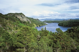
Skogafjellet
You have to travel to Scotland in order to find pine forests similar to those at Bømlo. The nearness to the sea has contributed in different ways to shaping one of the westernmost pine forests in Norway.


Urangsvågen-Rubbestadneset
In 1868 the first stone workers came to Rubbestadneset to take out the granite for the Skoltegrunns Pier, predecessor of the Skoltegrunns wharf in Bergen. Later granite was also taken out from the area, around Innværs Fjord and UransvågenN. The activity probably peaked around 1900, with over 40 men at work. 15 years later, it was finished.

Fitjarøyane
If we study the group of islands south of Selbjørns Fjord from the air or on a sea map, we will notice that many of the islands are elongated and lie systematically in rows. The islands are divided by long sounds, for example Trollosen, Nuleia and Hjelmosen, which are oriented in a south-southeast to north-northwesterly direction.

Aksnesholmane
There are especially many seabirds inwards along the fjords of western Norway. There are not many islets, either, so if the birds want to nest, it is not always easy to find good sites. At Aksnesholmane there is an impressive colony of gulls, and the locality has been protected since 1923.

