- Remove Small landforms filter Small landforms
- Remove Iron age filter Iron age
- Remove Sveio filter Sveio
- Remove Granvin, frå 2020 del av nye Voss herad filter Granvin, frå 2020 del av nye Voss herad
- Remove Coniferous forests filter Coniferous forests
- Remove Radøy, frå 2020 del av nye Alver kommune. filter Radøy, frå 2020 del av nye Alver kommune.
- Remove Masfjorden filter Masfjorden
- Remove Wetland filter Wetland

Granvinsvassdraget
After the ice age, Granvin Fjord reached all the way up under Skjervsfjossen waterfall. Just a thousand years later, as a result of the rising of the land after the ice melted, this whole inner part of the fjord freed itself of the sea and became Granvinsvatnet lake. In spite of this rise in elevation, this waterway is still navigable for fish: Sea trout have wandered into Granvinsvatnet in more recent times and evolved to become freshwater trout. And salmon and sea trout made the journey 13 kilometres up the Storelvi river.


Haugsdalen
Early in the 1900s there were much larger salt water deltas in Hordaland. But, essentially all of the larger river deltas got filled in and regulated for use in industry during the last century. Now, there is only Haugsdals delta left.

Matrehola
On a large gravel terrace in Matredalen (the Matre valley), a couple of kilometres from the coastal settlement Matre, lies Storseterhilleren, at the end of a large stone block that came rushing down from the mountain. The Matre river runs just over 100 metres to the east of the cave.


Toska
The peat bogs on Toska have been mined for peat since 1946, when the island got electricity. In this treeless coastal landscape, peat was the most important source of energy, and this took quite a toll on the bogs.

Hopsfjellet
On June 2nd, 1992, a big forest fire broke out in Sveio. The fire started southeast of Hopsfjellet. In a strong wind the flames spread quickly northward. Houses on the other side of the highway were threatened, but escaped unscathed. The burned area, which is easily visible about a 5 minute's drive south from the tunnel at the triple- junction, was made into a nature reserve in 1998. The intention was to ensure that the re-establishment of plant- and animal life would take place without disturbance.
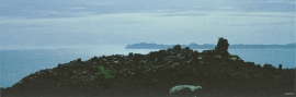
Tjernagel
For almost three thousand years Tjernagelshaugen (the Tjernagel cairn) has lain as a landmark at the Bømlo fjord. The poet Torarin mentions the cairn in his account of Knut the Mighty, who in the year of 1028 sailed from Denmark to Nidaros: “And in front of the old cairn at Tjernagel sailed soldiers sharp with peace”.

Myking
Between Lake Kvalheimsvatnet and Lake Mykingsvatnet, north of Grindheim, we find one of the biggest continuous lowland bogs in Hordaland. It is 500-600 metres across and a whole 2 kilometres long. Locally, the bog is called "Havet" .

Bjellandsvatnet
Lake Bjellandsvatnet is one of the richest wetland areas in Sveio. But, everything has its limit, and the supply of nutrients can be too much. This is what was about to happen in Lake Bjellandsvatnet.

